For historical information only, do not use for navigation or aviation purposes!
| Coordinates | N515203 E0134655 (WGS84) Google Maps |
| Elevation | 62m / 203 ft |
| Former East Germany (GDR) | District of Cottbus |
| Federal state | Brandenburg |
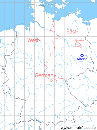
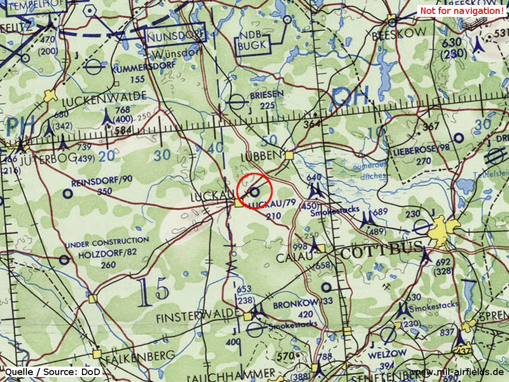
Germany during the Cold War Map
During World War II
Use
Luftwaffe airfield, opened in the 1930s.
Situation
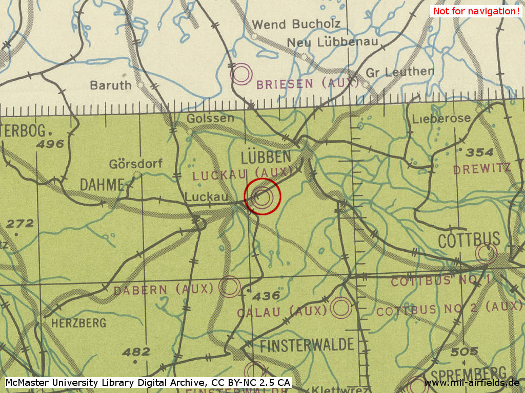
Alteno Airfield as "Luckau" in World War II on a US map from 1944
Source: McMaster University Library Digital Archive, Lizenz: Creative Commons Attribution-NonCommercial 2.5 CC BY-NC 2.5 CA
During the Cold War
Use
Reserve airfield for former East German Fighter Wing 1 (Jagdgeschwader 1, JG-1). It was one of only a few reserve airfields in East Germany with a hard surfaced runway.
In the 1960s
Overview
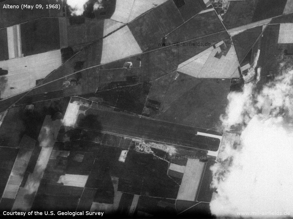
Satellite image from May 09, 1968 - Compared to 1965, the airfield now has paved takeoff heads and a circular taxiway - a configuration typical for East German auxilliary airfields.
Source: U.S. Geological Survey
History
1966: Observation by the US Military Liaison Mission: "Heavy airfield construction began at the natural surface near Alteno and continued throughout the year" /USMLM 1966/
In the 1970s
Overview
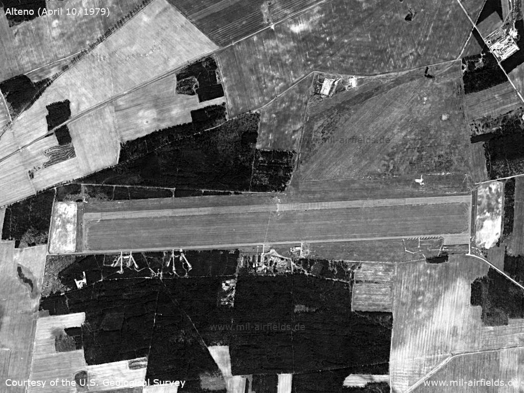
US satellite image from April 10, 1979
Source: U.S. Geological Survey
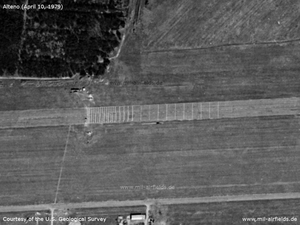
The runway has unusual markings - The markings were placed for the test of the aircraft arresting gear, which takes place at the time. The MiG-21 and MiG-23 aircraft were rolling from west to east (from left to right) and came to a stop on the marked area.
Source: U.S. Geological Survey
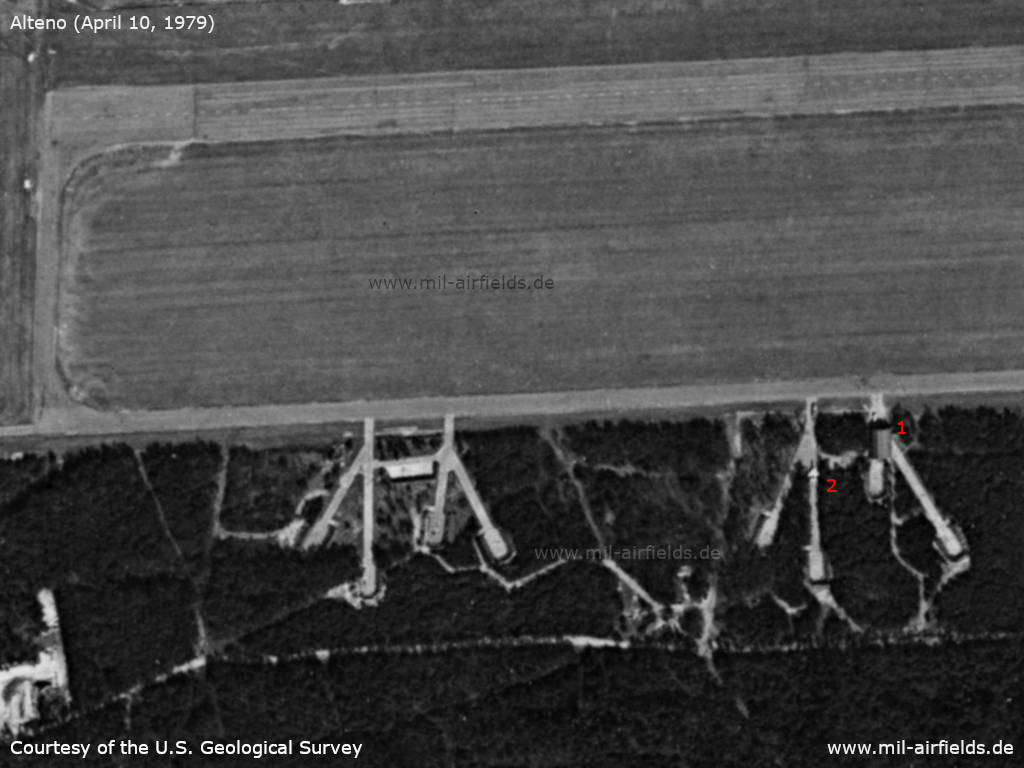
Western part of the airfield - 1: maintenance tent on the way to the boxes 1 and 2 (see text below), 2: aircraft, probably MiG-21
Source: U.S. Geological Survey
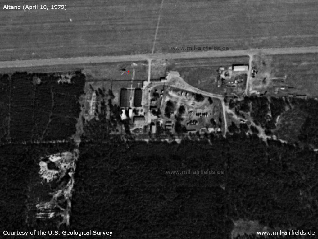
Installations - 1: helicopter
Source: U.S. Geological Survey
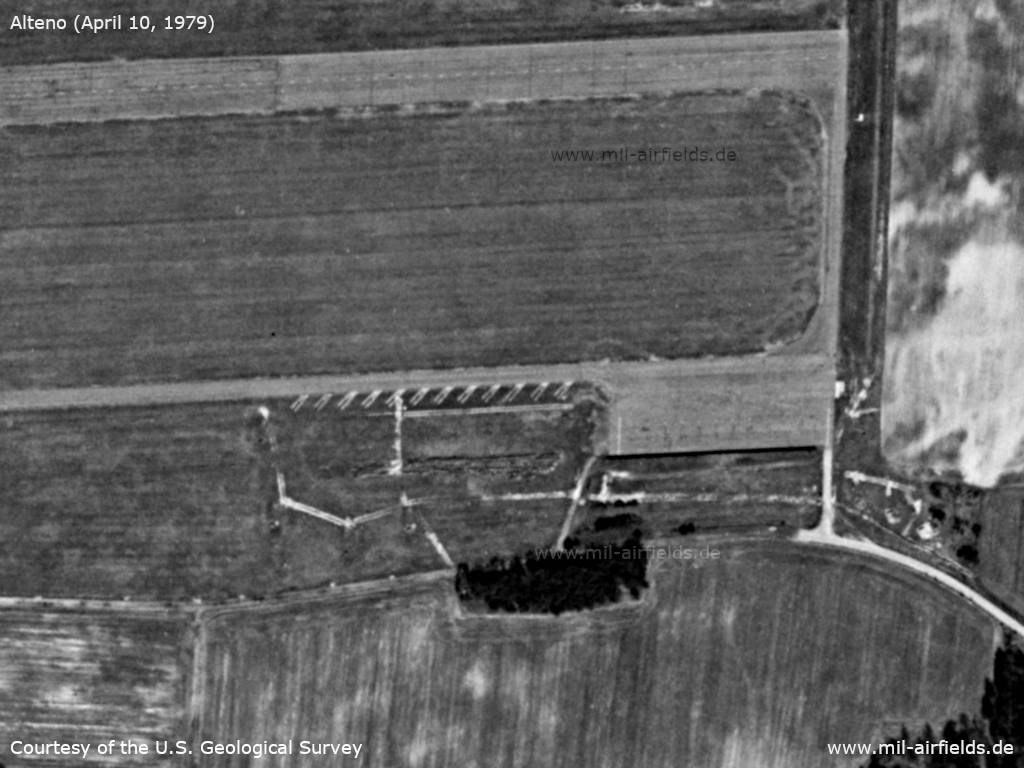
Eastern part: Flight line and parking lanes
Source: U.S. Geological Survey
Additional information
Alteno in the year 1978
The following information were provided by Mr. Buchholz. He was NCO squad leader for the radio station R-831. Many thanks!
Personalbestand:
- 12 - 15 Soldaten, 3 Unteroffiziere, einen Hauptfeldwebel und einen Offizier (Leutnant)
- Wachpersonal von ca. 12 - 15 Soldaten für die einzelnen Objekte Muni-Bunker, Tanklager und Hauptobjekt
- Personal für Wartung der Landebahnbeleuchtung und Scheinwerfer
- Einen Koch für die Versorgung des Personals
- Flugplatzleiter war ein Leutnant.
Es war alles ständig in Gefechtsbereitschaft. Wir hatten für alles Normzeiten. Die Normzeiten wurden täglich und ständig getestet. Flüge gab es nur, wenn Cottbus nach Alteno verlegt hat.
1977 wurde die MiG-23 von den Russen in Alteno getestet. Dabei ging es um den Test der Abfangnetze. Es waren ca. 10 russische Angehörige vor Ort.
Test of an aircraft barrier in 1979
Memories of Bernd Kahl - private 1st class (reserve) - about his time in Alteno (many thanks to you as well!):
Ich leistete meinen Grundwehrdienst bei der NVA vom Mai ´78 bis Oktober ´79 als Funker bei der Flugsicherstellung der 1. LVD ab. Bis Ende ´78 war ich auf dem Flugplatz Drewitz/Süd stationiert und wurde im Januar ´79 nach Alteno abkommandiert, weil aufgrund des Fanganlagentests erhöhter Wachmannschaftsbedarf bestand. In Alteno war ich von Mitte Januar 1979 bis irgendwann im Mai. So lange dauerten auch die Tests.
Der Test der Fanganlage fand also erst ab frühestens Januar ´79 statt, es sei denn, es gab zwei Tests. Am Test nahmen teil eine MiG-21 (oder ähnliches Modell) der NVA und eine MiG-23 unserer „sowjetischen Bruderarmee“! Erstere wurde mit demontierten Flügeln per Tieflader herangekarrt. Ich weiß auch davon, dass Fahrzeuge der alliierten Besatzungsmächte dies beobachtet haben (1978?). Die MiG-23 wurde durch einen russischen Piloten ohne jegliche Funk- oder Lichtbefeuerung gelandet. Er überflog die Piste nur je einmal links sowie rechts abgekippt und landete dann.
Beide Maschinen wurden in einem Wartungszelt untergestellt und instand gehalten, das auf der gemeinsamen Boxenzufahrt für die Boxen 1 und 2 stand. Dieses war mit einem eigenen Postenbereich abgesichert.
Die Postenbereiche waren:
- Wachlokal (für Objekt)
- Bombenlager
- Tanklager
- Reparaturzelt
- Längsflanke des Platzes im Wald gegenüber Objekt
Erstere drei waren eingezäunt, die beiden anderen wurden ´beschrieben´.
Gegner im eigentlichen Sinne gab es natürlich nicht, auch keine Neugierigen. Wir wurden nur ermahnt, das Auftauchen alliierter Fahrzeuge sofort zu melden und ansonsten außer Beobachten nichts zu tun. Besagte hatten übrigens nur den Transport "begleitet".
Während dieser Zeit waren geschätzt folgende Personen dort:
- Stammpersonal: 25 - 30 (inkl. Offiziere)
- Aufstockung: ca. 30
- Sowjetisches Militär: 5
- Firmenmonteure: 10
Unterbringung:
- 2 Zimmer in der Hauptbaracke: Wachpersonal (wo sich auch Küche befand)
- Zweite Baracke: Monteure; sowjetisches Militär; Zusatzoffiziere
- 2 Mannschaftszelte: Stammpersonal bzw. Speisezelt
- 1 "Ziehharmonika-Baracke": Zusatzpersonal
In the 1980s and early 1990s
Situation
Alteno Airfield on a map of the US Department of Defense from 1981
Source: ONC F-2 (1981), Perry-Castañeda Library Map Collection, University of Texas at Austin
Overview
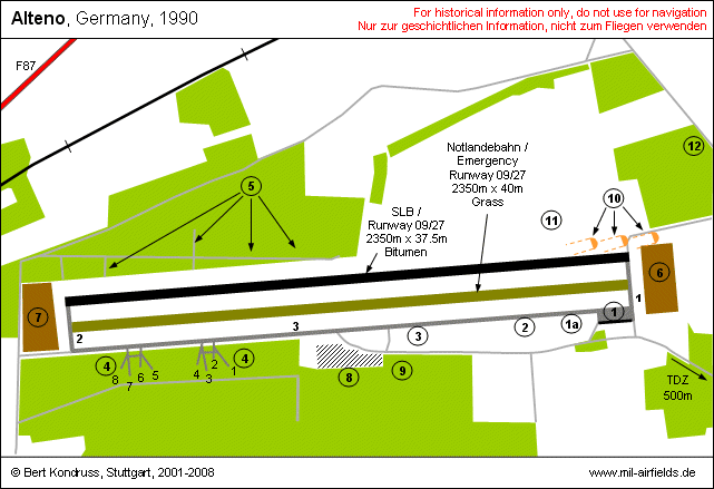
| 1, 2, 3 | Number of taxiway |
| (1) | Ramp 1 mit blast barrier (for jets and heavy transport aircraft), width 160 m |
| (1a) | Ramp 1a with taxi tanes (for jets) |
| (2) | Ramp 2 (for helicopter), with 300 m |
| (3) | Ramp 3 (for light transport aircraft), with 150 m |
| (4) | Dispersal areas with box-number |
| (5) | Additional dispersals |
| (6) | Earth stop area 200m x 260m |
| (7) | Earth stop area 200m x 250m |
| (8) | Airfield administration |
| (9) | Car pool |
| (10) | Landing lights |
| (11) | Mobile control tower and met office |
| (12) | Tanks |
Arm position: Ramp 1, direction 30° to runway centerline
Dearm position: Dispersal area, box number 7, direction 180°
Runways
Data for the year 1986:
- 09/27: 2350 m x 37,5 m Bit
- 09/27: 2300 m x 40 m Grass
The runway had a bearing strength of 300 kp/cm2. The earth stop areas were 25 m away from the thresholds. Taxiway 3 had a width of 11.25 m.
Threshold elevations: Threshold east: 62.49 m, threshold west: 61.74 m.
Until 1989/1990:
In 1989, the runway designator was 08/26. The dimension of the grass runway was said to be 1800 m x 50 m.
Lights
Runways and taxiways had no color markings. Prisms (height: 0.7 m, width: 0.6 m) were standing to both sides of the runway with a distance of 200 m. The landing thresholds were not numbered. Runway and taxiways had edge lights. The emergency runway was marked by red/white-colored cones at both sides, the distance between the cones was 200 m. The approach sectors were not marked.
For 1986, the lighting system was given as:
- coded beacon KNS 8 e
- light landing system LLA
- taxiway lights MLOKp
- emergency landing lights R 15
- 4 landing flood lights ARM-90
- coded beacon KNS 8 e
- light landing system LLA
- taxiway lights MLOKp
- emergency landing lights R 15
- 4 landing flood lights ARM-90
For 1989, the installations were summarized as light installation SP-2, set up for main landing direction.
Radio beacons
- LOM 27: 444,5 "AO", 4550 m to threshold 27, Type: Par 8ss mit MR 48
- LMM 27: 317 "A", 1000 m to threshold 27, Type: Par 8ss mit MR 48
The identification codes were derived from the first and last letter of the call sign "ARNO". This was a common practice in the Warsaw Pact.
The locator beacons were operated partially automated. The switch-on time was 20 min.
Radar
Radar service was provided by Radar Company 413 (Funktechnische Kompanie 413, FuTK-413) in Taubendorf.
Radio communication
The call sign of the airfield was "ARNO". Like at serveral reserve airfields, the first and the last letter of the call sign matched to those of the village (ARNO - ALTENO). Call sign of the tower controller was "ARNO-START", direction finder "ARNO-PELENG".
The direction finder was not located as usual at the 1000m-point. Instead it was at the airfield.
Equipment in the year 1986:
- Flight director: 2 radios R 831/24
- Duty coxswain: 1 radio R 801
- VHF direction finder ARP-6 with radio R 824
- Flight director: 2 radios R 831/24
- Duty coxswain: 1 radio R 801
- VHF direction finder ARP-6 with radio R 824
Telephone
Commercial telephone number: Amt Luckau 2098.
Maps
The following maps are from the document "Regulations for flying at the Alteno decentralization airfield" from 1986. The document was classified as "Secret" (Vertrauliche Verschlusssache) and contains the rules for the operation of the airfield.
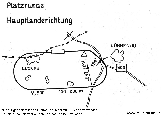
Alteno traffic pattern for main landing direction
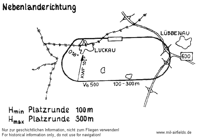
Alteno traffic pattern for secondary landing direction
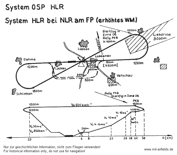
Locator approach for main landing direction
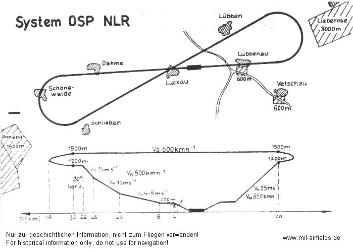
Locator approach for secondary landing direction
Units
The airfield was assigned to Fighter Wing 1. It was operated by Reserve Airfield Detachment 1 (Feldflugplatzkommando 1, FFpK-1, postbox 44112).
Installations
Der airfield had the former East German National People's Army installation ID 06/005. The area was 273.4 ha and there were quarters for 116 people. The airfield was not fenced.
Images
Pictures from 1990:
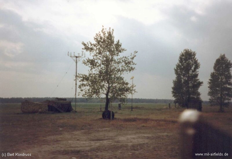
Mobile control tower north of the runway
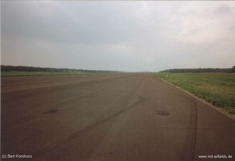
Runway, looking west
Today
Use
The airfield is closed. For some years, the area was home of the "Mehrzweckanlage-Luckau" (MZA--Luckau), used for car races and other events. Now solar park.
Approach and aerodrome maps
Formerly secret maps for pilots of the National People's Army (NVA) of the GDR
Approach charts Alteno Airfield
Approach charts Alteno Airfield
Links
1945-199x
- Ausbildungsjahr 1966/67 - Short description about an accident of a MiG-17F at Alteno in the year 1967
- Ausstattung des Verlegeflugplatzes Alteno - Pictures and description
- Verlegung zum Feldflugplatz Alteno - Report about deployments of fighter wing 1 (JG-1) from Cottbus: Air Base and Holzdorf: Air Base to Alteno
- http://www.history.hqusareur.army.mil/uslmannual.htm (offline): USMLM Unit History 1969
- http://www.history.hqusareur.army.mil/uslmannual.htm (offline): USMLM Unit History 1971
- http://www.history.hqusareur.army.mil/uslmannual.htm (offline): USMLM Unit History 1975
- http://www.history.hqusareur.army.mil/uslmannual.htm (offline): USMLM Unit History 1978 - Short notice about a deployment of MiG-21 to Alteno at the 20 june 1978.
- Die Flugzeugnotfanganlage ATU-G/1A - Videos showing tests with MiG-21 and MiG-23 at Alteno in 1977.
199x until today
- http://www.untergrund-brandenburg.de/Sub_Sites/NVA... - Untergrund Brandenburg Alteno airfield of fighter wing 1
- http://www.sachsenschiene.net/bunker/flp/flp_42.ht... - Sachsenbunker Alteno radio beacon
Bibliography
until 1945
- Ries, Karl; Dierich, Wolfgang: "Fliegerhorste und Einsatzhäfen der Luftwaffe" Motorbuch Verlag Stuttgart, 1993 - Allied map
1945-199x
- Michels, Jürgen; Werner, Jochen: "Luftfahrt Ost 1945-1990" Bernard & Graefe Verlag, Bonn, 1994 - Shows a MiG-23 testing an arresting gear at Alteno.
- /USMLM 1966USMLM 1966/:
United States Military Liaison MissionUnited States Military Liaison Mission: "Unit History 1966Unit History 1966" - Bußmann, Kleest, Freundt: ""11-80, katapultieren Sie!"" AeroLit - Verlag und Medienvertrieb, Berlin, 2004 - Picture of a MiG-17 which was destroyed during landing at Alteno in 1967.
- Banach, Bußmann, Girke, Meißner, Willisch, Freundt: "MiG, Mi, Su & Co." AeroLit - Verlag und Medienvertrieb, Berlin, 2002 - Picture of a MiG-17 at Alteno.
- Billig, Detlef; Meyer, Manfred: "Flugzeuge der DDR, IV. Band" TOM Modellbau, Friedland, 2004 - Colour pictures of MiG-23 testing an arresting gear at Alteno in 1979.
Airfields in the vicinity
- 353°/19km Brand: Air Base (Brand-Briesen, Аэродром Бранд)
- 041°/20km Biebersdorf: Helipad 3022 (HSLP / HLP 3022)
- 043°/23km Krugau: Helipad 3036 (HSLP / HLP 3036)
- 150°/25km Bronkow: Airfield
Categories
Military Airfields GermanyMilitary Airfields in former East GermanyAir bases of former National People's ArmyRecommended
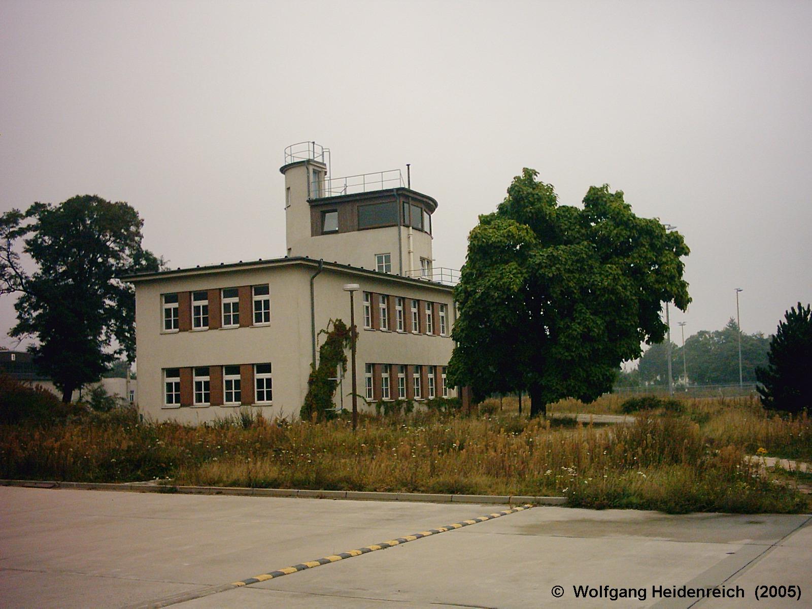
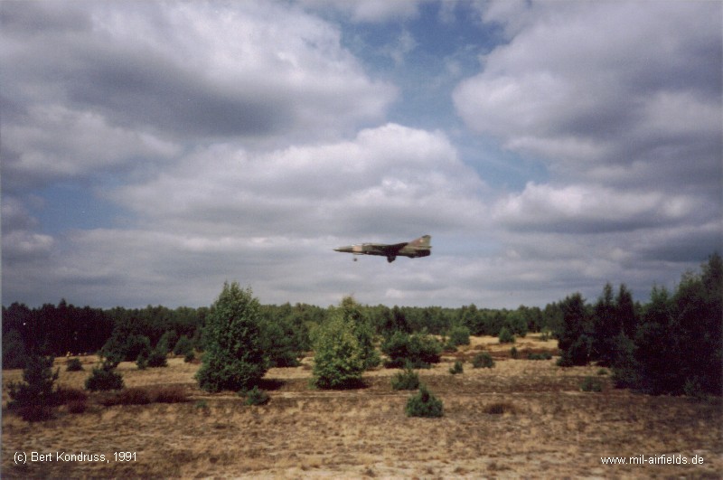
Image credits are shown on the respective target page, click on the preview to open it.
 Follow mil-airfields on Facebook