For historical information only, do not use for navigation or aviation purposes!
| Coordinates | N503227 E0093825 (WGS84) Google Maps |
| Elevation | 1000 ft |
| Location indicator | EDEX (1990) |
The history of the Cold War airfields: Fulda
Overview
Fulda was an US Army airfield, which was used as a helicopter base until the early 1990s. It was located at the strategically important Fulda Gap, which was viewed by the West as a probable place for a Soviet tank attack because the potential deployment area of the East in Thuringia offered the shortest route to the important Rhein-Main area in the west. Therefore, many transport, observation and combat helicopters were stationed in Fulda.
The airfield was located just 19 km from the inner-German border and was geographically within the Air Defense Identification Zone (ADIZ), the air surveillance zone along the demarcation line. However, the area around the airfield was exempted from the ADIZ to an altitude of 2,000 feet, probably to simplify flight operations. Today, the airfield is closed and the new district Fulda-Galerie is located on the site. The former control tower and the fire brigade building are still preserved.
Location
Federal State of Hessen (Hesse).
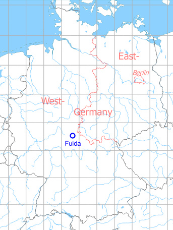
Germany during the Cold War
During the Cold War
Use
US Army airfield.
Situation
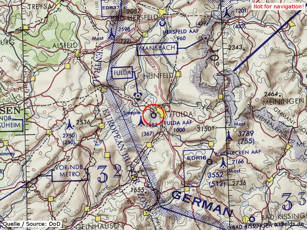
Fulda Army Airfield AAF on a map of the US Department of Defense from 1972 - The blue dotted strip about 20 km east of Fulda is the inner-German border. The blue line about 11 km west of the field is the regular ADIZ border. The hexagonal symbol 8 km north-west is the radio beacon Fulda VORTAC. 32 km north-east of the airfield stands the Mansbach TACAN at the beginning of the southern corridor to Berlin. (ONC E-2 (1972), Perry-Castañeda Library Map Collection, University of Texas at Austin /PCL MC/)
Overview
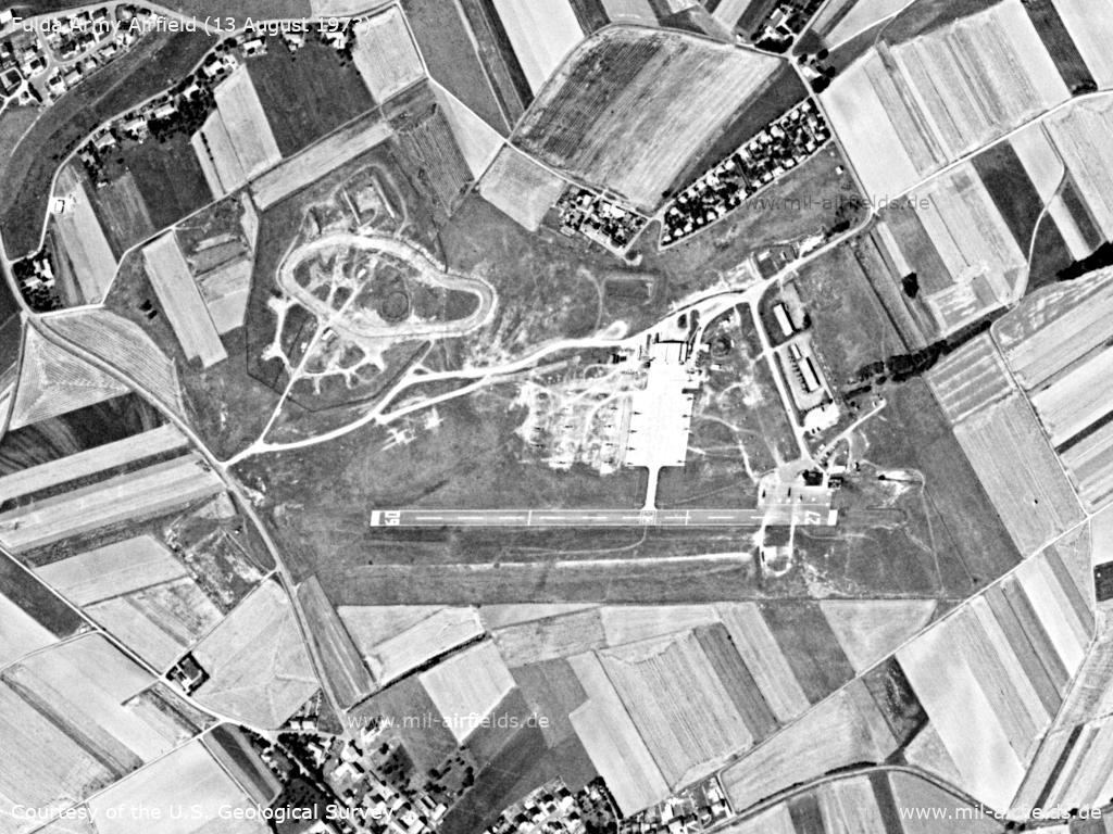
Fulda Army Airfield on a US satellite image from ... - The Hawk anti-aircraft missile site adjacent to the northwest appears to be empty.
Source: U.S. Geological Survey
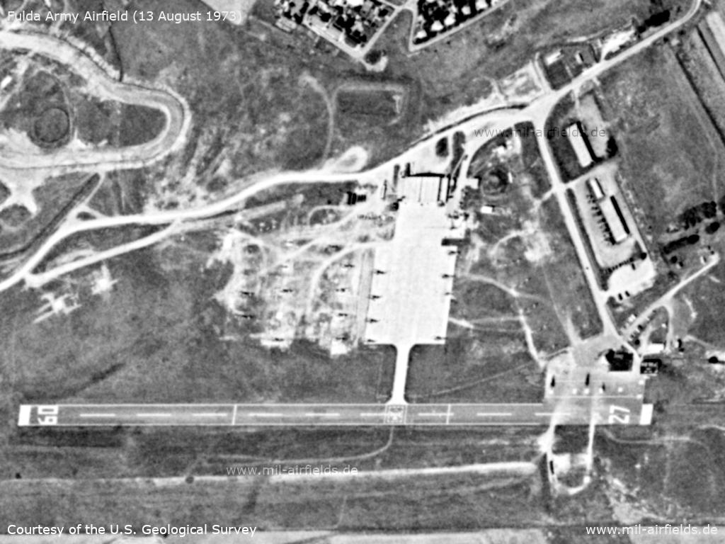
Enlargement - There are about 20 helicopters in the picture.
Source: U.S. Geological Survey
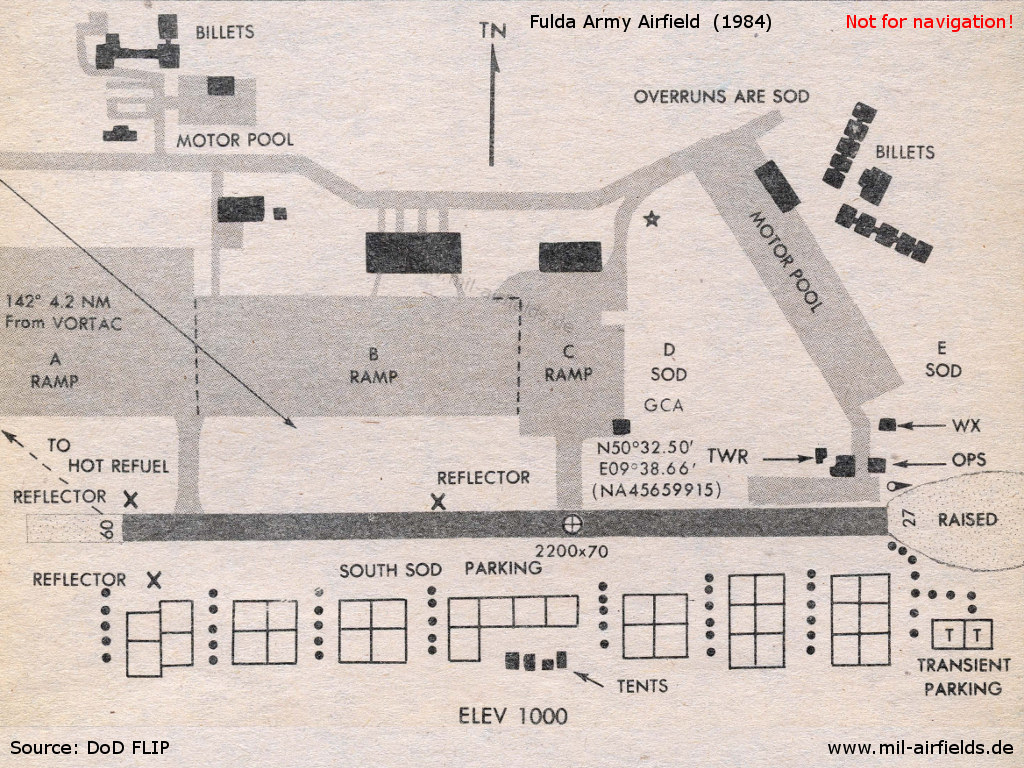
Airfield map from 1984 - Compared with the images from 1973, the facilities have been significantly expanded. More paved parking areas have been added in the north (Ramp A and B), and helicopters can be parked in the grass in the south (South sod parking).
Source: US DoD
| 09/27 | Runway, 2,200 feet long (671 m), 70 feet wide (21 m) |
| Circle with cross | The marking on the runway indicates the aerodrome reference point (with the coordinates) |
| OVERRUNS ARE SOD | The overruns at both ends of the runway are grass |
| REFLECTOR | Radar reflectors |
| A/B/C RAMP | Ramps |
| D/E/SOUTH SOD | Grass areas |
| PARKING | The squares in the south mark individual parking spots |
| TRANSIENT PARKING | Parking for visiting aircraft |
| HOT REFUEL | Spot to refuel with running engines |
| Star symbol | Rotating aerodrome beacon |
| TWR | Control tower |
| GCA | Approach radar (Ground Controlled Approach) |
| WX | Weather station |
| OPS | Base Operations |
| TENTS | Zents |
| MOTOR POOL | Motor pool |
| BILLETS | Billets |
Runways
At the end of the 1980s the designation of the runway was changed from 09/27 to 08/26 due to the changed magnetic direction.
Data for the year 1971:
- 09/27: 671 m x 21 m Asphalt
Data for the year 1990:
- 08/26: 616 m x 21 m Asphalt
Lights
The airfield had a rotating airfield beacon. The runway had lights on the sides.
Radio beacons
Until the end of the 1960s, a non-directional beacon (NDB) with the identification FUL stood about 4 km southeast of the field. It was not until the end of the 1980s that Fulda AAF received its own non-directional beacon, which was directly on the spot.
Data for the year 1990:
- DVORTAC: 112.1 "FUL", 141°/4.2NM to fld
- NDB: 441 "FDA", at field
Radar
Since the end of the 1970s, Fulda had had an approach radar with an Aerodrome Surveillance Radar (ASR) and a Precision Approach Radar (PAR).
Telephone
Phone numbers in the telephone networks of the US armed forces:
Military 2364-548/748/814 (1970s)
DSN 321-3xxx (1990)
Military 2364-548/748/814 (1970s)
DSN 321-3xxx (1990)
Units
4-11 ACR (12th Avn Bde, V Corps) 26 AH-1F, 27 OH-58C, 17 UH-60A, 3 EH-60C (1990)
Today
Use
Closed. On the site, the Fulda-Galerie district has been created.
 Follow mil-airfields on Facebook