For historical information only, do not use for navigation or aviation purposes!
| Coordinates | N542246 E0100839 (WGS84) Google Maps |
| Elevation | 101 ft |
| Federal state | Schleswig-Holstein |
| Region | Kieler Förde |
| Location indicator | EDGK (197*), EDCK (1990), EDHK |
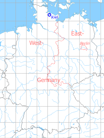
Germany during the Cold War Map
The history of the Cold War airfields: Kiel Airport
During the 1920s/1930s
General
Zu diesem Zeitpunkt gab es zwei dicht nebeneinander liegende Flugplätze: Den Landflughafen Kiel-Voßbrook und den Wasserflugplatz Kiel-Holtenau.
Information from the Aeronautical Information Publication as of February 1929
For historical information only, do not use for navigation or aviation purposes!
I. Level Airport Kiel-Voßbrook
Information from the Aeronautical Information Publication as of March 1930
For historical information only, do not use for navigation or aviation purposes!
I. Level Seaplane Airport Kiel-Holtenau
Business owner / Administrator
Kieler Flughafengesellschaft m. b. H., Kiel-Holtenau, Flughafen Kiel-Voßbrook.
Cable address: Holstenflug Kiel.
Cable address: Holstenflug Kiel.
Luftdienst G. m. b. H., Flugleitung Kiel-Holtenau,
Drahtanschrift: Luftdienst Kiel-Holtenau.
Drahtanschrift: Luftdienst Kiel-Holtenau.
Transport companies / Airlines
Deutsche Luft Hansa A. G., Flugleitung Kiel,
Flughafen Kiel-Voßbrook.
Cable address: Lufthansa Kiel.
Flughafen Kiel-Voßbrook.
Cable address: Lufthansa Kiel.
Luftverkehr Schleswig-Holstein G. m. b. H., Kiel-Holtenau,
Flughafen Kiel-Voßbrook.
Cable address: Holstenflug Kiel.
Flughafen Kiel-Voßbrook.
Cable address: Holstenflug Kiel.
Situation
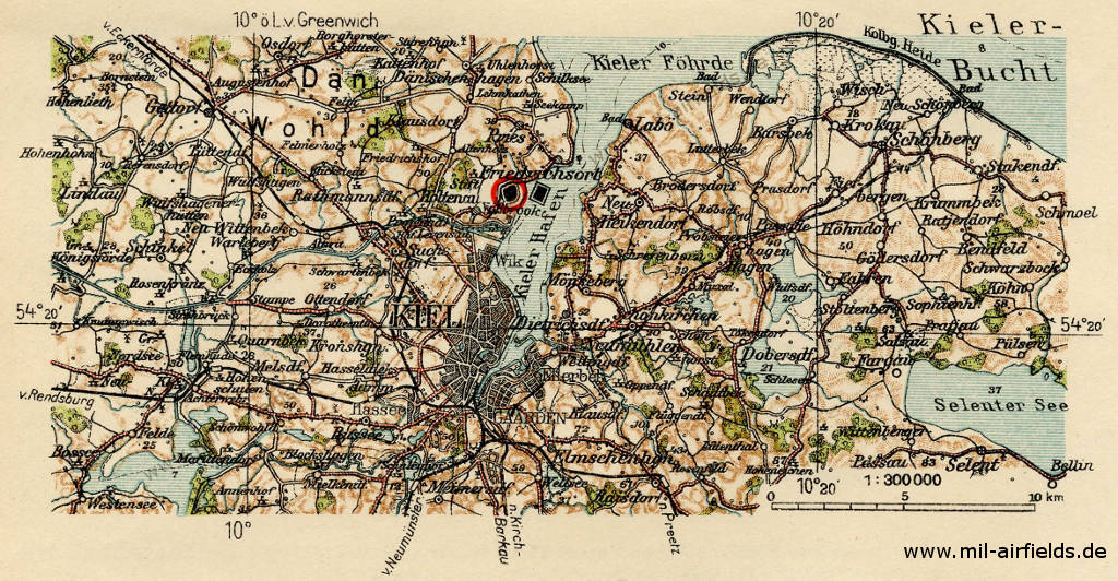
Location of the land airport (black symbol with the red circle) and the seaplane base (black symbol to the right of it)
Source: Flughandbuch für das Deutsche Reich (1929)
Land-based aerodrome
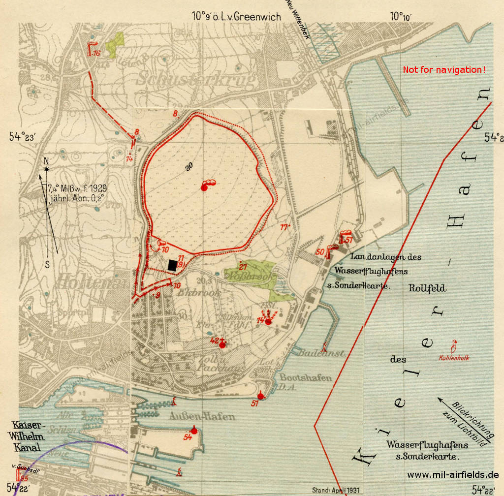
Map with land-based airport (center - top left) und seaplane airport (bottom right)
Source: Flughandbuch für das Deutsche Reich (1929/1931)
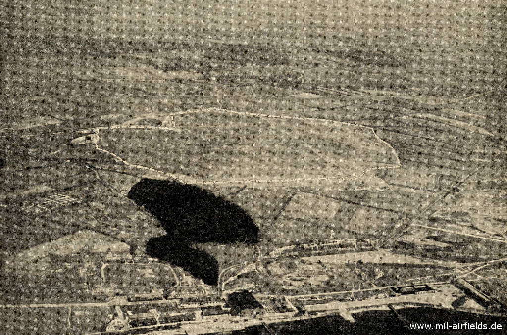
Aerial picture (ca. 1929) - Looking about northwest. The land-based airfield is in the middle of the picture, at the bottom you can see the seaplane base.
Source: Flughandbuch für das Deutsche Reich (1929)
Seaplane station
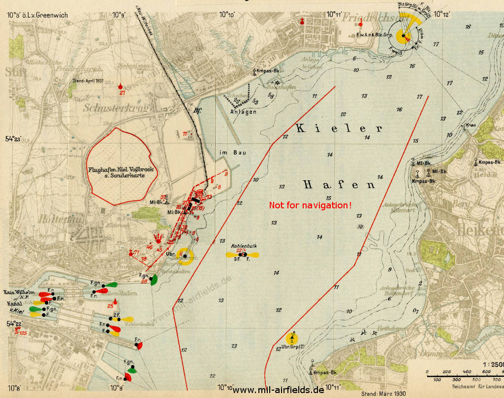
Map of Kiel harbor with land and seaplane station
Source: Flughandbuch für das Deutsche Reich (1929/1931)
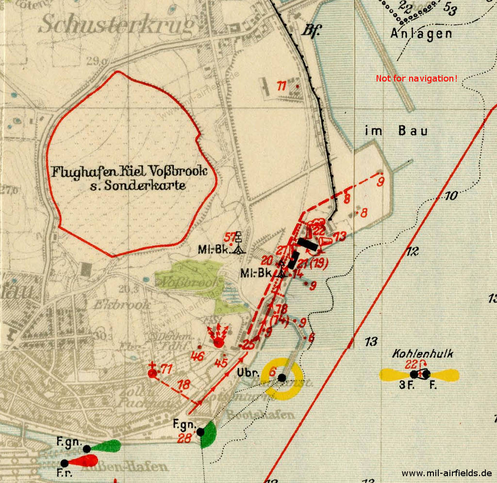
Enlargement - The seaplane base is at the center - bottom right.
Source: Flughandbuch für das Deutsche Reich (1929/1931)
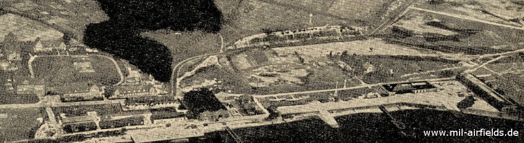
Aerial picture (ca. 1929) - Two airplanes can be seen ashore.
Source: Flughandbuch für das Deutsche Reich (1929)
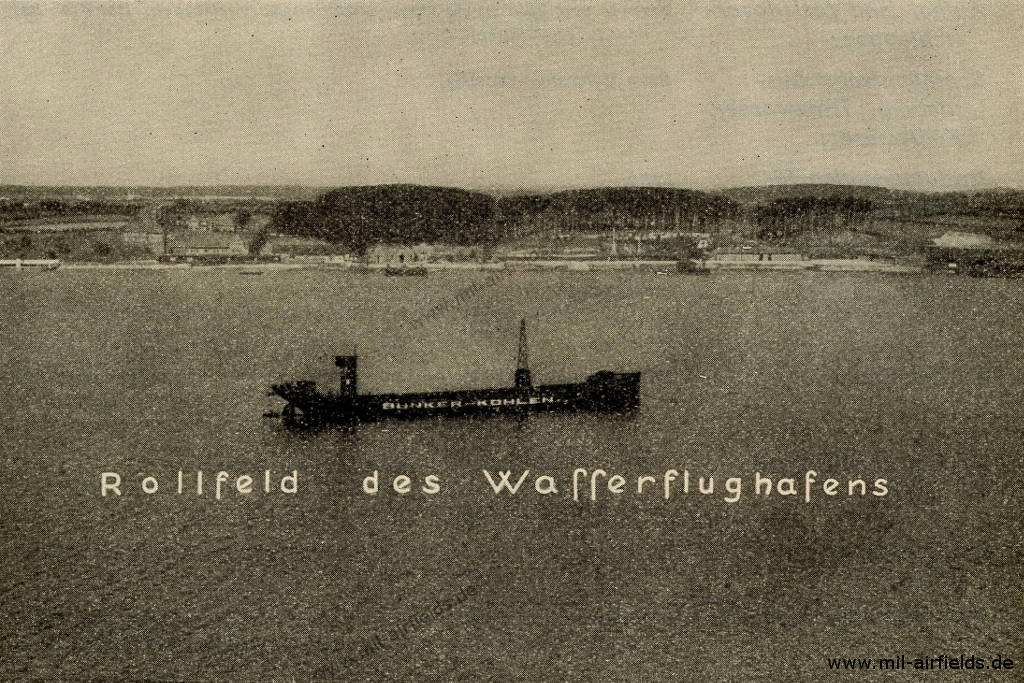
Coal Hulk "Bunker-Kohlen" in the Kiel Canal / Fjord inlet in front of the water aerodrome
Source: Flughandbuch für das Deutsche Reich (1929)
Airfield characteristics at daytime
1 km north of the Holtenau locks of the Kaiser Wilhelm Canal. On the roof of the hangar the inscription "Kiel". Landing signs are constantly displayed. Smoke oven. Windsock on the mast at the southern edge of the runway next to the administration building. Runway borders in the east and north marked by red and white panels, in the south and west by fencing.
Als Rollfeld gilt die Wasserfläche des Kieler Hafens von der Mündung des Kaiser-Wilhelm-Kanals bis Leuchtturm Friedrichsort. Die Auswahl für Start und Landung bleibt dem Flugzeugführer überlassen. Auf einem Hallendach der Uferanlagen die weiße Aufschrift "Kiel-Holtenau". Windsack auf Hallendach. Etwa 700 m südöstlich der Landanlagen eine fest verankerte Kohlenhulk.
Airfield characteristics at night
No permanent night lighting. On request at the administrator, landing lights consisting of green, white and red fires in a row parallel to the wind direction. Land from green over white to red, to the right of the row. The nearby Holtenau locks and the Kaiser Wilhelm Canal are constantly lit.
Keine ständige Nachtbefeuerung. Die Mündung des Kaiser-Wilhelm-Kanals sowie die Kohlenhulk sind stets befeuert und gut erkennbar. (Vgl. Admiralitätskarten und Verzeichnis der Leuchtfeuer und Signalstellen aller Meere, Teil I, Ostsee, lfd. Jahrgang).
Runways, taxiways, aprons
Good sod on loamy sandy soil.
Shortest rolling distance: 700 m in all directions.
Shortest rolling distance: 700 m in all directions.
Water conditions
The stream changes with the different wind directions; it is only weak and has no influence on landings.
Beach
Sanding and shallow; ice only forms during prolonged severe frost.
Anchorage ground
Sandy clay; black silt; good.
Towing aid
Can be requested from the administrator.by radio telegraphy, telephone or shooting of red stars near the buildings of the airport.
Disembarking
A motorboat, a speedboat and two rowing boats are available for disembarkation.
Mooring
Buoys are available to line aircraft ropes.
Slope and widths of the slipways
1:10, north slipway 13 m wide, south slipway 9 m wide.
Deepest point of the slipways under water
1,5 m.
Normal water depth at the slipways
2 m.
Slipways
Available for seaplanes. A trolley for large aircraft (Junkers G 24) is available.
Pickup and loading devices
Tractor and spill as well as lifting devices available. The crane has a lifting capacity of 4.0 t.
Nautical equipment, drinking water, cooling water
Available from the administrator.
Ship rescue station
Labö.
Shortest rolling distance
1500 m.
Hangars
1 aircraft hangar 40 x 28 m, gate width 35 x 8 m. The hangar contains 2 trolleys with a load capacity of 1.0 t each.
Two hangars:
Hangar I: 60.8 x 20 m, height 5 m, gate width 30 m,
Hangar II: 90.8 x 20 m, height 5 m, gate width 30 m.
Hangar I: 60.8 x 20 m, height 5 m, gate width 30 m,
Hangar II: 90.8 x 20 m, height 5 m, gate width 30 m.
Workshops
Will be installed in the 40 x 7 m annex to the hall. Spare parts for various aircraft and engine types of the Deutsche Luft Hansa in stock.
Contains all equipment necessary for the repair of metal and wooden aircraft. Electricity: 220/380 Volt three-phase. Spare parts for Junkers and Heinkel seaplanes in stock.
Fuel equipment
Tank farm for 10 000 l and tap for manual operation next to the administration building.
For 10,000 litres of petrol and benzene each, 1 tanker truck for 500 litres. Each 5000 l petrol and benzene always in stock, furthermore 10,000 l standard fuel of the Deutsche Luft Hansa A. G.
First aid in the case of accidents
It's provided by airfield police station. Next doctor in Holtenau (0.5 km away). Ambulances of the city of Kiel available on call.
Is provided by fitters trained in medical service. Medical room available. Next doctor in Holtenau (2.5 km away).
Customs, passport
Customs clearance possible. Passport control by airfield police station.
Customs clearance possible, passport control by airfield police office.
Maps and charts
Available from Luftverkehr Schleswig-Holstein G. m. b. H. in 1 : 300 000.
Telephone connections
| Business owner, administrator, night lighting | Kiel-Holtenau 294 | |
| Transport companies: Deutsche Luft Hansa A. G., Flugleitung Kiel: Kiel-Holtenau 221 Luftverkehr Schleswig-Holstein G. m. b. H.: Kiel-Holtenau 294 | ||
| Airfield police station: Kiel-Holtenau 225 | ||
| Doctor: Kiel-Holtenau 294 | ||
| Fire alarm station, ambulance: Kiel 802 (fire brigade) | ||
| Taxi cabs: Kiel-Holtenau 250 |
| Business owner, administrator: Kiel-Holtenau 235 and 275. | ||
| Airfield police station: Holtenau 284. | ||
| Doctors: Kiel-Holtenau 245 and 270 | ||
| Hospitals: Kiel-Holtenau 8050 and 8200 | ||
| Taxi cabs: Kiel-Holtenau 80 and 250 | ||
| Fire alarm: Kiel 802 |
Accommodation of passengers
In the hotels and inns in Holtenau and Kiel. Restaurant in the administration building.
In Holtenau and Kiel. Own office in the reception building.
Connections
Shuttle service during scheduled take-offs and landings. Post bus line Friedrichsort-Kiel, hourly traffic. Demand stop in front of the administration building. Taxi cabs on call.
Timetable
Summer 1928
The timetable for summer of 1928 shows the following scheduled flights:
(Days: 1=Monday ... 7=Sunday)
(Days: 1=Monday ... 7=Sunday)
123: Hamburg (Fuhlsbüttel) - Kiel (Holtenau) - Flensburg (Schäferhaus) - Wyk - Westerland
- Deutsche Luft Hansa A.G.:
123456– | Hamburg 17:00 - 17:45 Kiel 18:00 - 18:35 Flensburg 18:45 - 19:15 Wyk 19:25 - 19:40 Westerland
The section Flensburg - Wyk - Westerland will only be opened on 16 June and will only be in operation until 15 September 1928. - Deutsche Luft Hansa A.G.:
123456– | Westerland 08:00 - 08:15 Wyk 08:25 - 08:55 Flensburg 09:05 - 09:40 Kiel 09:55 - 10:40 Hamburg
The section Flensburg - Wyk - Westerland will only be opened on 16 June and will only be in operation until 15 September 1928.
124: Lübeck/Travemünde (Priwall) - Kiel (Holtenau) - Flensburg (Schäferhaus) - Westerland - Wyk
- Deutsche Luft Hansa A.G.:
123456– | Lübeck/Travemünde 16:25 - 16:55 Kiel 17:10 - 17:45 Flensburg 18:00 - 18:40 Westerland 18:50 - 19:05 Wyk - Deutsche Luft Hansa A.G.:
123456– | Wyk 08:15 - 08:30 Westerland 08:40 - 09:20 Flensburg 09:35 - 10:10 Kiel 10:25 - 10:55 Lübeck/Travemünde
Departures and arrivals by time
| Days | Time | Dep/Arr | Route | Operator | Aircraft type | to/from |
|---|---|---|---|---|---|---|
| 123456– | 09:40 | Arr | 123 | Deutsche Luft Hansa A.G. | Westerland - Wyk - Flensburg | |
| 123456– | 09:55 | Dep | 123 | Deutsche Luft Hansa A.G. | Hamburg | |
| 123456– | 10:10 | Arr | 124 | Deutsche Luft Hansa A.G. | Wyk - Westerland - Flensburg | |
| 123456– | 10:25 | Dep | 124 | Deutsche Luft Hansa A.G. | Lübeck/Travemünde | |
| 123456– | 16:55 | Arr | 124 | Deutsche Luft Hansa A.G. | Lübeck/Travemünde | |
| 123456– | 17:10 | Dep | 124 | Deutsche Luft Hansa A.G. | Flensburg - Westerland - Wyk | |
| 123456– | 17:45 | Arr | 123 | Deutsche Luft Hansa A.G. | Hamburg | |
| 123456– | 18:00 | Dep | 123 | Deutsche Luft Hansa A.G. | Flensburg - Wyk - Westerland |
Spring/Summer 1939
The timetable for spring/summer of 1939 shows the following scheduled flights:
(Days: 1=Monday ... 7=Sunday)
(Days: 1=Monday ... 7=Sunday)
127: Berlin (Tempelhof) - Kiel (Holtenau) - Flensburg (Schäferhaus) - Wyk - Westerland
- Deutsche Lufthansa, Junkers Ju 52:
123456– | Berlin 10:50 - 12:20 Kiel 12:30 - 12:55 Flensburg 13:05 - 13:25 Wyk 13:35 - 13:50 Westerland
(24 June - 31 August 1939) - Deutsche Lufthansa, Junkers Ju 52:
123456– | Westerland 14:30 - 14:45 Wyk 14:55 - 15:15 Flensburg 15:25 - 15:50 Kiel 16:00 - 17:30 Berlin
(24 June - 31 August 1939)
145: Kiel (Holtenau) - Hamburg (Fuhlsbüttel) - Berlin (Tempelhof)
- Deutsche Lufthansa, Junkers Ju 52:
123456– | Kiel 07:00 - 07:30 Hamburg 07:40 - 09:00 Berlin - Deutsche Lufthansa, Junkers Ju 52:
––––––7 | Hamburg 10:00 - 11:20 Berlin - Deutsche Lufthansa, Junkers Ju 52:
––––––7 | Berlin 20:00 - 21:20 Hamburg - Deutsche Lufthansa, Junkers Ju 52:
123456– | Berlin 20:00 - 21:20 Hamburg 21:35 - 22:05 Kiel
Departures and arrivals by time
| Days | Time | Dep/Arr | Route | Operator | Aircraft type | to/from |
|---|---|---|---|---|---|---|
| 123456– | 07:00 | Dep | 145 | Deutsche Lufthansa | Junkers Ju 52 | Hamburg - Berlin |
| 123456– | 12:20 | Arr | 127 | Deutsche Lufthansa | Junkers Ju 52 | Berlin |
| 123456– | 12:30 | Dep | 127 | Deutsche Lufthansa | Junkers Ju 52 | Flensburg - Wyk - Westerland |
| 123456– | 15:50 | Arr | 127 | Deutsche Lufthansa | Junkers Ju 52 | Westerland - Wyk - Flensburg |
| 123456– | 16:00 | Dep | 127 | Deutsche Lufthansa | Junkers Ju 52 | Berlin |
| 123456– | 22:05 | Arr | 145 | Deutsche Lufthansa | Junkers Ju 52 | Berlin - Hamburg |
During World War II
Use
Luftwaffe airbase.
Situation
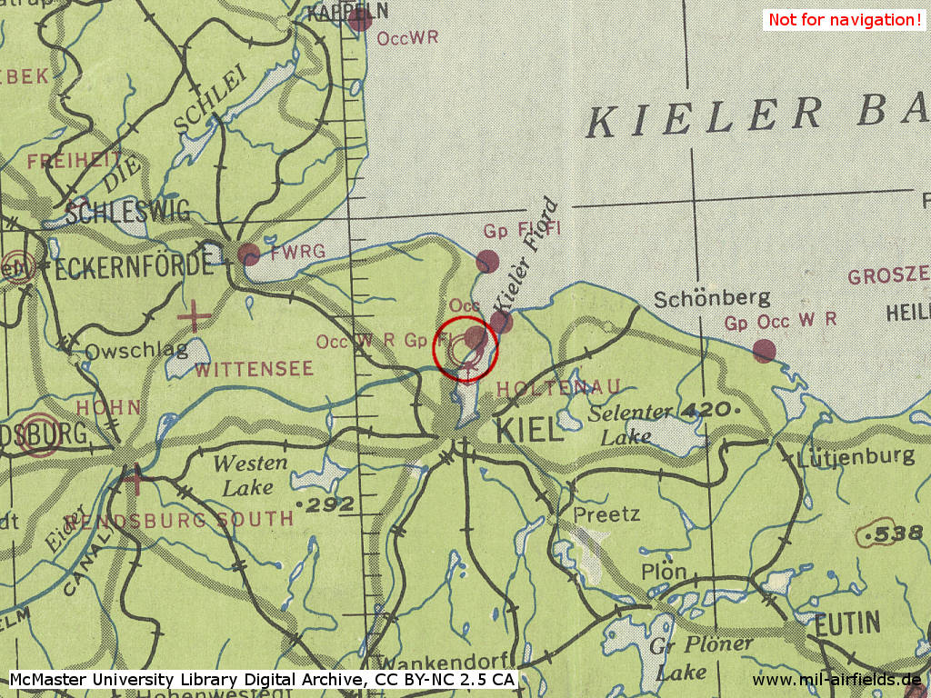
Kiel Holtenau Airfield in World War II on a US map from 1943
Source: McMaster University Library Digital Archive, License: Creative Commons Attribution-NonCommercial 2.5 CC BY-NC 2.5 CA
Overview
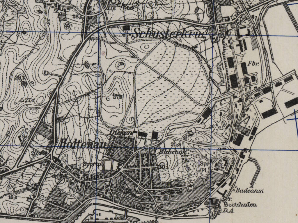
Kiel Holtenau Airfield on a US map from 1953 - The map should show approximately the state of development during the Second World War.
Source: AMS M841 GSGS 4414, Courtesy Harold B. Lee Library, Brigham Young University
During the Cold War
Use
German navy airbase.
In the 1970s
Situation
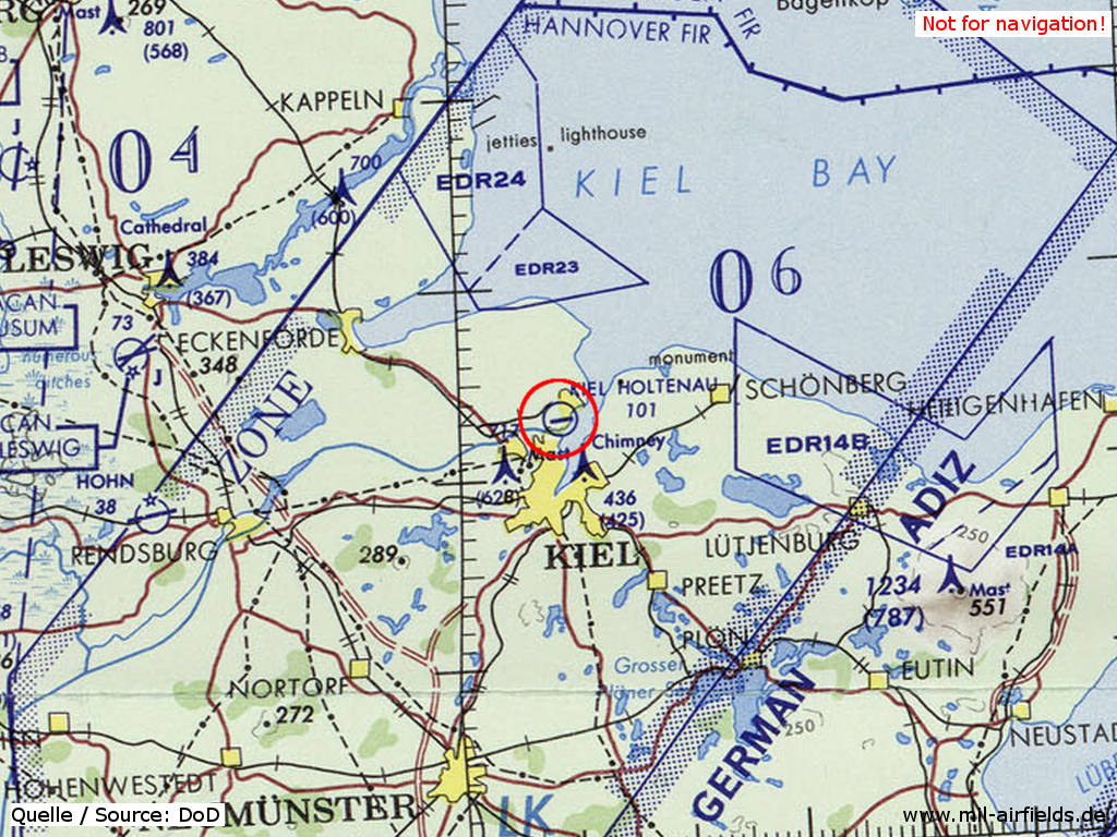
Kiel Holtenau Airfield on a map of the US Department of Defense from 1972
Source: ONC E-2 (1972), Perry-Castañeda Library Map Collection, University of Texas at Austin
In the 1980s and early 1990s
Runways
- 08/26: 450 m x 35 m Grass
- 08/26: 1400 m x 30 m Asphalt
Radio beacons
- NDB: 383.5 "KIL", 082° 0.6NM to THR08
Units
Naval Wing 5 (Marinefliegergeschwader 5, MFG 5) with Sikorsky Sea King and Dornier Do-28D.
Today
Use
Regional airport.
Images
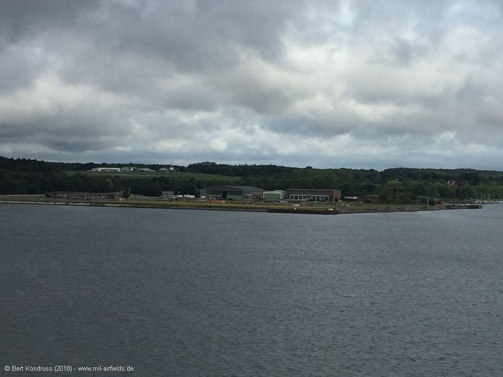
View from the Kiel Canal (2018) - In the foreground the former area of the Naval Wing 5 (MFG 5), in the background the Kiel airfield.
Links
- http://www.airport-kiel.de/ - Airport Kiel
Airfields in the vicinity
- 095°/31km Todendorf: Army Airfield
- 280°/36km Brekendorf: Highway Strip
- 259°/40km Hohn: Air Base (Rendsburg)
- 283°/42km Schleswig: Air Base (Jagel, RAF Schleswigland)
Recommended
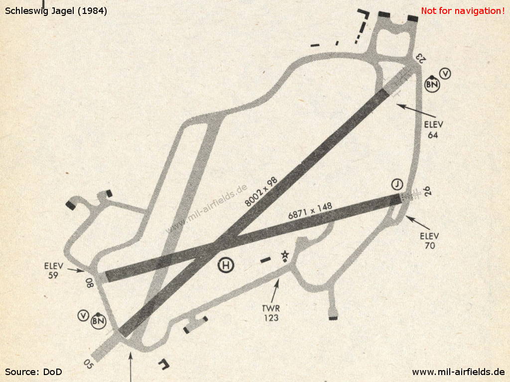
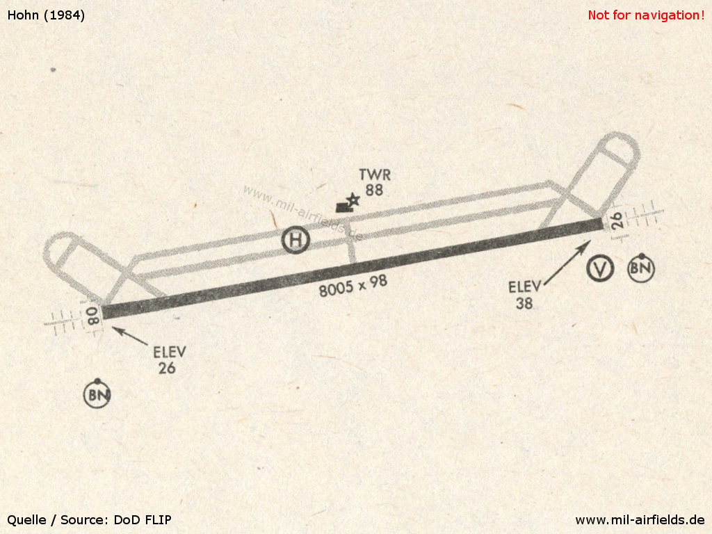
Image credits are shown on the respective target page, click on the preview to open it.
 Follow mil-airfields on Facebook