For historical information only, do not use for navigation or aviation purposes!
| Coordinates | N533429 E0140341 (WGS84) Google Maps (approximate location) |
| Former East Germany (GDR) | District of Neubrandenburg |
| Federal state | Mecklenburg-Vorpommern (Mecklenburg-Western Pomerania) |
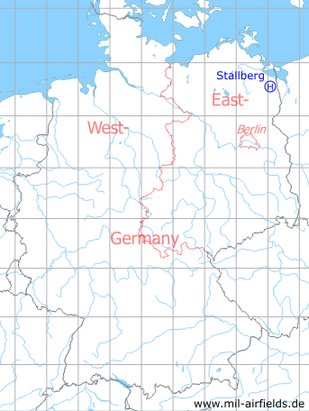
Germany during the Cold War Map
The history of the Cold War airfields: Stallberg
Location of airfield
Northern limits of Stallberg
Usage during the Cold War
Helipad 3330 for HQ Anti-aircraft missile regiment 23 (FRR-23) of former East German Air Force (NVA LSK/LV)
Use today
Closed.
Runways, taxiways, aprons
Dimensions: 150 m x 150 m,
Main takeoff and landing direction: 320°,
Surface: Grass (drill ground),
Capacity: day 4 Helicopters, night 1 helicopter.
Main takeoff and landing direction: 320°,
Surface: Grass (drill ground),
Capacity: day 4 Helicopters, night 1 helicopter.
Telephone
Stabsnetz S1 47335-88
Airspace and procedures
Usable at day during good weather conditions.
Alert time: 60 minutes.
Alert time: 60 minutes.
Obstacles
Buildings: direction 0° - 360°;
Trees: direction 0° - 360°, height 15 m.
Trees: direction 0° - 360°, height 15 m.
Airfields in the vicinity
- 143°/15km Löcknitz: Helipad 3380 (HSLP 3380)
- 296°/15km Eichhof: Helipad 3334 (HSLP / HLP 3334)
- 157°/16km Bergholz: Agricultural Airfield
 Follow mil-airfields on Facebook