For historical information only, do not use for navigation or aviation purposes!
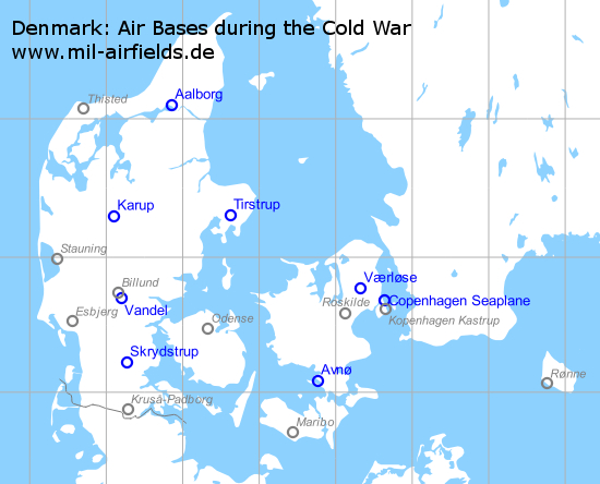
Military airfields in Denmark (8)
| Aalborg: Air Base |
| Avnø: Airfield |
| Copenhagen: Seaplane Base |
| Karup: Air Base |
| Skrydstrup: Air Base |
| Tirstrup: Air Base |
| Værløse: Air Base |
| Vandel: Air Base |
Aalborg: Air Base
Flyvestation Aalborg, Aalborg Lufthavn
For historical information only, do not use for navigation or aviation purposes!
| Coordinates | N570542 E0095118 (WGS84) Google Maps |
| Elevation | 10 ft |
| Location indicator | EKYT |
Usage during the Cold War
Royal Danish Air Force (Flyvevåbnet) base.
In the 1950s
Radio beacons
- NDB: 325 "OZJ", 268°/1.4 NM to field
Radar
GCA
Communication
- Tower 3023.5, 118.3, 120.7, 117.9 (mil)
In the 1960s
Runways
- 09L/27R: 2650 m x 80 m
- 09R/27L: 2350 m x 23 m
- 04/22: 1400 m x 80 m
- 15/33: 1800 m x 80 m
Radio beacons
- NDB: 331 "AAL", 266°/4.2 NM to field
- VOR: 116.7 "AAL", 266°/4.0 NM to field
- TACAN: CH 18 "AAL", 266°/4.0 NM to field
Radar
ASR, PAR
Radio communication
- GCA 120.7, 247.8, 119.9, 262.1, 385.4, 344.0, 140.58, 116.1
- Tower 362.3, 120.7, 118.3, 293.0, 287.8, 257.8, 117.9
In the 1980s
Runways
- 09L/27R: 2650 m Asphalt/Concrete
Radio beacons
- L: 398 "GL"
- VORDME: 116.7 "AAL"
- TACAN: CH 114 "AAL"
- ILS 27: 109.9 "YT"
Radio communication
- Approach 250.3, 120.7, 362.3
- GCA 225.4, 119.9, 122.6, 270.1
- Tower 285.3, 118.3, 257.8, 122.1
Avnø: Airfield
Flyvestation Avnø, Avno
For historical information only, do not use for navigation or aviation purposes!
| Coordinates | N550503 E0114547 (WGS84) Google Maps |
| Elevation | 12 ft |
| Location indicator | EKAV |
In the 1960s
Radio communication
- Tower 362.3, 122.1, 104.4
Today
Use
Closed, used as center for nature.
Copenhagen: Seaplane Base
For historical information only, do not use for navigation or aviation purposes!
| Coordinates | N554100 E0123800 ca. (WGS84) Google Maps |
Location of airfield
In Koge Bay east of the city.
Usage during the Cold War
Royal Danish Navy seaplane base.
Current usage
Closed.
Airfields in the vicinity
Karup: Air Base
Flyvestation Karup, Karup Lufthavn
For historical information only, do not use for navigation or aviation purposes!
| Coordinates | N561750 E0090602 (WGS84) Google Maps |
| Elevation | 166 ft |
| Location indicator | EKKA |
Usage until 1945
Grove Luftwaffe air base.
In the 1950s
Radar
GCA
Radio communication
- Approach 106.38
- Tower 117.0
In the 1960s
Runways
- 09L/27R: 3048 m x 23 m
- 09R/27L: 2933 m x 46 m
- 04/22: 1045 m x 80 m
- 14/32: 1030 m x 80 m
Radio beacons
- TACAN: CH 37 "KAR", 094°/3.5 NM to field
Radar
ASR, PAR
Radio communication
- Approach 362.3, 247.2
- GCA 385.4, 344.0, 140.58, 292.5, 240.2
- Tower 257.8, 379.0, 117.9
In the 1980s
Runways
- 09L/27R: 3050 m Concrete
- 09R/27L: 2933 m Concrete
- 04/22: 1045 m Asphalt
Radio beacons
- TACAN: CH 37 "KAR"
- ILS 27: 108.3 "KR"
Radio communication
- Approach 355.2, 362.3, 124.5
- GCA 119.9, 236.1, 260.1, 344.0, 385.4, 122.2
- Tower 122.1, 257.8, 340.2
Today
Use
Air base, regional airport.
Installations
Additional runway about 2 km northwest of the actual airfield.
Skrydstrup: Air Base
Flyvestation Skrydstrup, Vojens Lufthavn, Fliegerhorst Hadersleben
For historical information only, do not use for navigation or aviation purposes!
| Coordinates | N551315 E0091602 (WGS84) Google Maps |
| Location indicator | EKSP |
Usage until 1945
Luftwaffe air base.
Usage during the Cold War
Royal Danish Air Force (Flyvevåbnet) base.
In the 1950s
Communication
- Approach 109.08
- Tower 105.84
- Homer 109.08
In the 1960s
Radio beacons
- VOR: 115.4 "SKP", at field
- TACAN: CH 39 "SKP", at field
Radio communication
- Approach 362.3, 305.5, 122.2
- Radar 140.58, 251.1, 261.8, 385.4, 344.0, 116.1
- Tower 320.1, 257.8, 122.2, 117.9
In the 1980s
Runways
- 11L/29R: 3030 m Asphalt
Radio beacons
- VORTAC: 110.4/CH 41 "SKR"
Radar
ASR, PAR
Radio communication
- Approach 236.5, 362.3, 122.2
- GCA 377.0, 119.9, 260.0
- Tower 122.1, 257.8, 310.1
Today
Use
Air base, regional airport.
Tirstrup: Air Base
Flughafen Aarhus, Tirstrup Lufthavn
For historical information only, do not use for navigation or aviation purposes!
| Coordinates | N561812 E0103709 (WGS84) Google Maps |
| Elevation | 81 ft |
| Location indicator | EKAH |
Usage until 1945
Luftwaffe air base.
In the 1960s
Runways
- 10R/28L: 2743 m x 46 m
- 10L/28R: 2569 m x 23 m northern taxiway
- 15/33: 1128 m x 76 m Grass
Radio beacons
- NDB: 391 "OZD"
Radio communication
- Approach 362.3, 238.1, 122.3
- Radar 262.8, 322.8, 385.4, 362.3, 344.0, 140.58
- Tower 288.2, 257.8, 117.9
In the 1980s
Runways
- 10L/28R: 2569 m Concrete
- 10R/28L: 2708 m Concrete/Asphalt
Radio beacons
- L: 391 "TU"
- TACAN: CH 91 "TIR"
- ILS 28: 111.1 "TR"
Radio communication
- Approach 122.3, 285.2, 362.3
- GCA 123.3, 310.3
- Tower 286.7, 122.1, 257.8
Today
Use
Regional airport.
Værløse: Air Base
Flyvestation Værløse, Vaerlose
For historical information only, do not use for navigation or aviation purposes!
| Coordinates | N554609 E0121929 (WGS84) Google Maps |
| Elevation | 58 ft |
| Location indicator | EKVL |
Usage until 1945
Air base.
In the 1950s
Radio communication
- Approach 109.08
- Tower 117.0
- Homer 107.64
In the 1960s
Runways
- 10/28: 2469 m x 46 m
Radio beacons
- NDB: 398 "VS", 101°/6.4 NM to field
- TACAN: CH 87 "VLL", 101°/6.9 NM to field
Radio communication
- Approach 362.3, 240.8
- Radar 140.58, 246.2, 261.8, 385.4, 344.0
- Tower 257.8, 237.2, 119.1, 117.9
In the 1980s
Runways
- 10/28: 2469 m x Concrete
Radio beacons
- NDB: 398 "VS"
- TACAN: CH 87 "VLL"
Radar
ASR, PAR
Radio communication
- Approach 260.2, 362.3, 122.2
- GCA 290.4, 310.4, 344.0, 385.4, 123.3, 122.1
- Tower 122.1, 235.8, 257.8, 122.2
Today
Use
Closed.
Airfields in the vicinity
- 116°/22km Copenhagen: Seaplane Base
Vandel: Air Base
For historical information only, do not use for navigation or aviation purposes!
| Coordinates | N554153 E0091144 (WGS84) Google Maps |
| Elevation | 241 ft |
| Location indicator | EKVA |
In the 1960s
Radio communication
- Approach 362.3, 296.3, 122.2, 119.9
- Radar 344.0, 119.9, 385.4, 316.2, 301.9, 140.58
- Tower 257.8, 237.2, 122.2, 117.9
Airspace and procedures
The airfield is activated by NOTAM.
In the 1980s
Runways
- 09L/27R: 2450 m Concrete
Radar
ASR, PAR
Radio communication
- Approach 119.25, 296.7, 257.8
- GCA 123.3, 122.1, 311.3, 295.4, 344.0, 385.4
- Tower 122.2, 240.2, 257.8
Telephone
(05) 88-52-00
Installations
Was there an emergency runway about 1.7 km south of the airfield? Was an emergency runway beginning at the eastern end of the main runway, leading to the east-southeast?
Hero image: Landing of a Danish F-35 Draken at Karup during exercise Reforger '82 (Source: US DoD, Scene Camera Operator: TSGT Ken Hammond)
Recommended

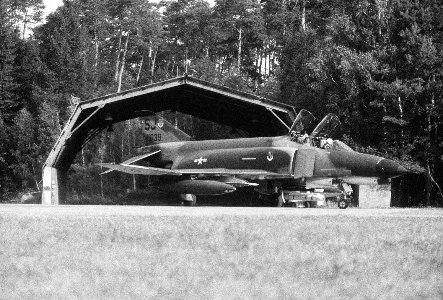

Image credits are shown on the respective target page, click on the preview to open it.