For historical information only, do not use for navigation or aviation purposes!
| Coordinates | N535243 E0140907 (WGS84) Google Maps |
| Elevation | 93 ft |
| Former East Germany (GDR) | District of Rostock |
| Federal state | Mecklenburg-Vorpommern (Mecklenburg-Western Pomerania) |
| Region | Island of Usedom, Baltic Sea, Oder lagoon, Szczecin Lagoon, Zalew Szczeciński |
| Location indicator | ETHD, EDAH |
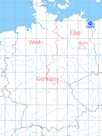
Germany during the Cold War Map
The history of the Cold War airfields: Garz / Heringsdorf
During World War II
Use
Luftwaffe airbase (Fliegerhorst).
Situation
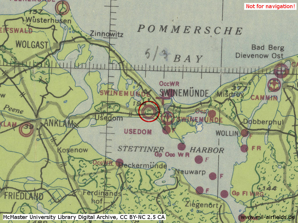
Garz Airfield in World War II on a US map from 1943
Source: McMaster University Library Digital Archive, License: Creative Commons Attribution-NonCommercial 2.5 CC BY-NC 2.5 CA
Overview
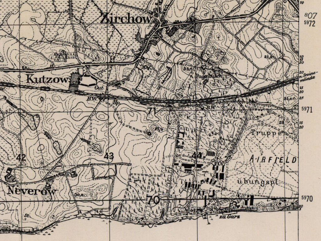
Garz airfield on a US map from 195x - Recognizable are the old runway system, the buildings of the former air base as well as the connecting railway. In the south is the Stettiner Haff (Szczecin Lagoon).
Source: AMS M841 GSGS 4414, Courtesy Harold B. Lee Library, Brigham Young University
During the Cold War
Use
Airfield of the East German Air Force. It was used for the temporary deployment of wings with construction measures at the home airfields. It was also used by the East German Interflug airlines as "Heringsdorf".
In the 1940s
History
CIA report from September1949
The Garz airfield (N 54/L 20) airfield is located between Garz and the "Haff" and borders a ridge on the north which limits the view of the field. ... could not go near the airfield since it was heavily guarded by Soviet Air Force patrols.
16.08.1949: Four northbound fighters took off in formation about 4 p.m. with fair visibility. The aircraft landed again forty minutes later. There was no flying until the evening. Description of the fighters: Radial engine, retractable landing gear, elliptical wings and rounded off wing tips, elevator assembly of the same shape.
18.08.1949: A U-2 biplane took off at 10 a.m. heading east. Four fighters of the above type took off at 11 a.m. and did acrobatics in the vicinity of the airfield, above the cumulus clouds. A biplane landed at 12:10 p.m. A westbound biplane took off at 7 p.m. There was no other flying. Heavy antiaircraft gun firing was heard from the direction of Usedom (N 54/L 00) for ten minutes about 11 a.m.
16. und 18.08.1949 Motor vehicles which were occupied by Soviet Navy soldies were observered on the Ahlbeck - Garz road.
Comment
a. ... on the same day observed fighters practicing at the Garz airfield. ... the unit stationed at the airfield is not known.
b: It is reported that the fighter unit concerned is assigned to the Soviet Navy Air Force, Baltic Sea Fleet.
Source: /CIA RDP82-00457R003500540004-4/
CIA report from October 1949
a. Garz airfield lies 2 1/2 km woutheast of Zirchow and 2 km southwest of Garz village. Its northern boundary, 400 meters from the field proper, is the dismantled Swinemuende-Usedom-Berlin railroad line; woods mark its southern limits. There are guards at the hangars and throughout the area, and frequent controls are made in the Garz-Zirchow area.
b. The well-kept grass field contains a northwest-southeast runway, 25 meters wide and 2 km long. Concrete hangar aprons occupy the northwestern edge of the field.
c. On observation date, two Boston-Douglas planes were parked in front of a closed hangar. Airfield workers claim that the hangar contains twelve seldom-used YAK type planes and that training missions are flown only once every 4-6 weeks. The unit gets its supplies from Swinemünde. Sirens sounded frequently during the nights of 12 and 13 August, but there was no air activity.
d. The field, suitable for all aircraft types, has an DF(?) station and boundary lights. The fuel dump consists of several buried railroad tank cars. Buildings are intact, some in process of being overhauled.
Comment The sole available airfield guide states that the runway at Garz is 3,000-4,500 feet long.
Source: /CIA RDP82-00457R003300440012-1/
CIA report from October 1949
1. The Garz (N 54/L 20) airfield, located between the "Haff" and a ridge, has an about 2,500-foot runway running parallel to the shore. Three hangars and two stone buildings, as far as could be seen, were available at the field.
2. Intensive flying, mostly local flying, was done between 6 and 11 a.m. on 16 August 1949. Besides a biplane and a speedy fighter, most of the aircraft observerd were two-seater monoplanes, low-wings with rounded off wing tips and in-line engine.
3. During two hours of observation ten outbound and five inbound motor vehicles ... were observed at the airfield entrance ... The airfield was occupied by Soviet Air Force and Navy units.
Comment The Garz airfield was not previously known to be occupied. Previous reports gave reason to believe that the airfield is assigned to the Soviet Naval Air Force, Baltic Sea Fleet. According to this report, it must be assumed that either a training unit for fighter pilots or a ground attack unit is stationed at the Garz airfield.
Source: /CIA RDP82-00457R003400380008-9/
In the 1950s
Overview
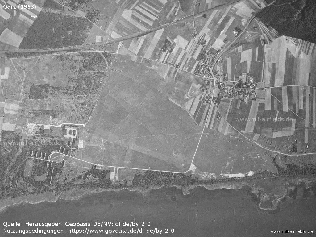
Source: Landesamt für innere Verwaltung M-V, Amt für Geoinformation, Vermessung und Katasterwesen - www.geoportal-mv.de, Data licence Germany – attribution – version 2.0, www.govdata.de/dl-de/by-2-0
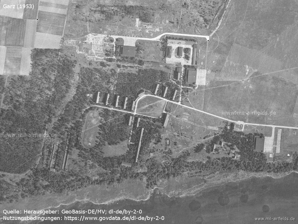
Barracks
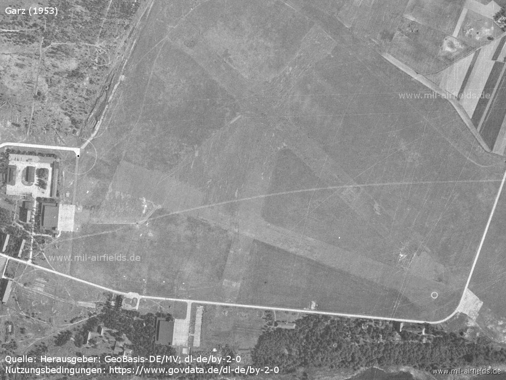
Airfield
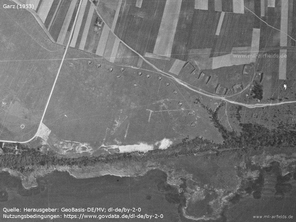
Large and small aircraft revetments in the east of the field
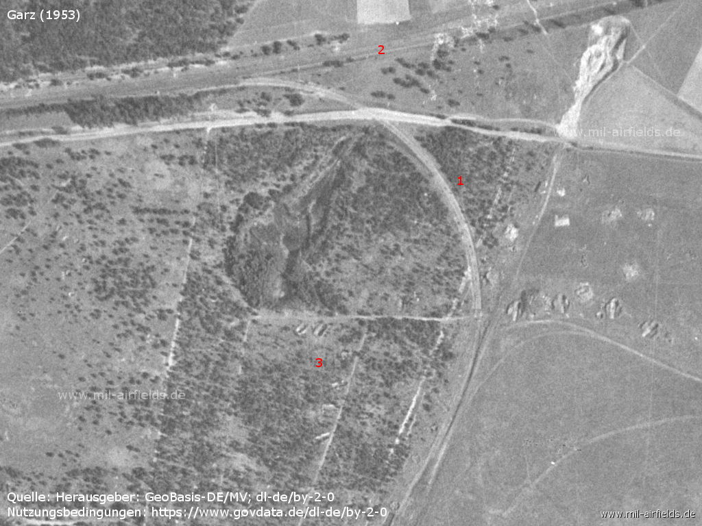
Former railway spur - 1: former railway siding to the airfield, 2: former railway line Ducherow-Karnin-Swinemünde, 3: revetments
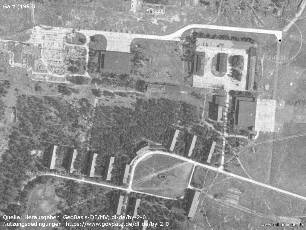
Barracks and hangars
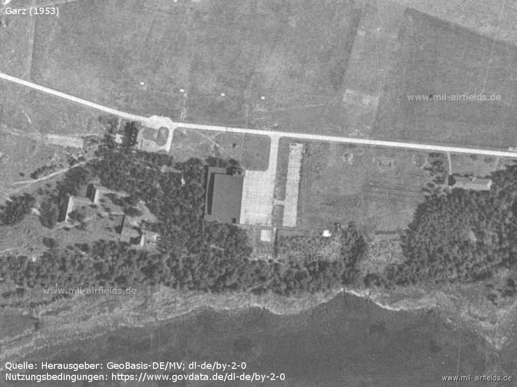
Hangar
In the 1960s
Overview
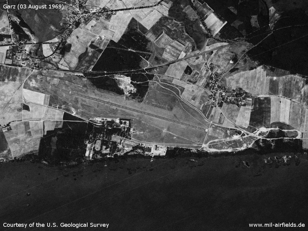
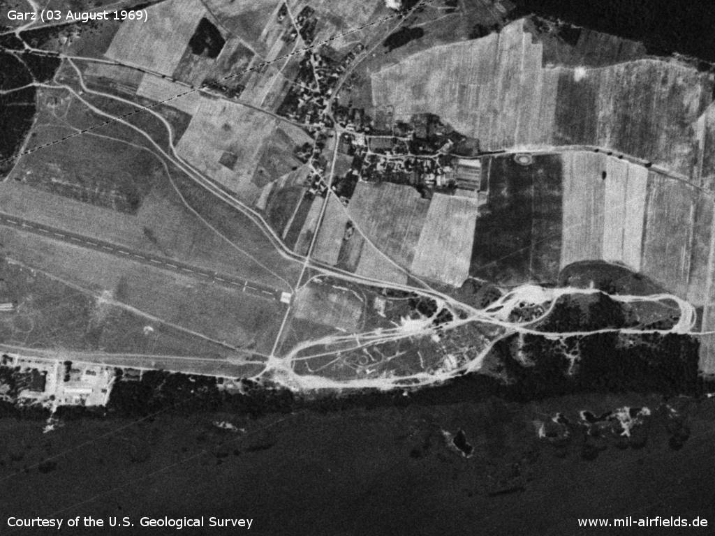
Garz Airfield on a US satellite image from 03 August 1969 - The airfield is located directly at the Oderhaff.
Source: U.S. Geological Survey
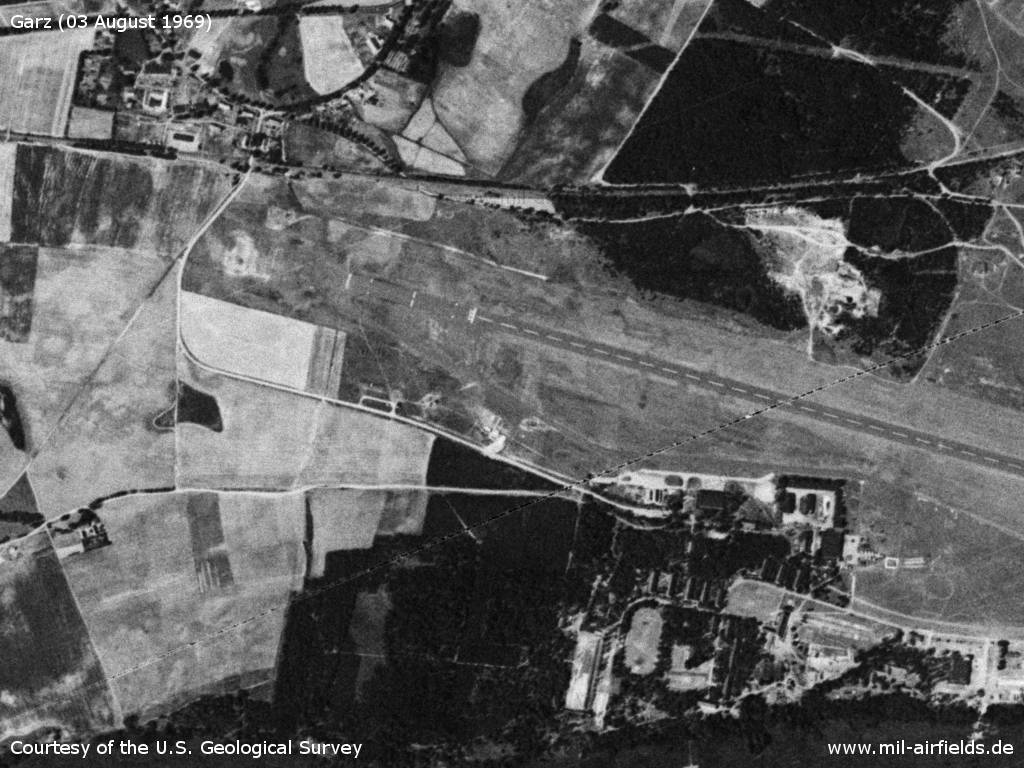
Western part
Source: U.S. Geological Survey
Eastern part - There is a military training area east of the airfield.
Source: U.S. Geological Survey
In the 1970s
Situation
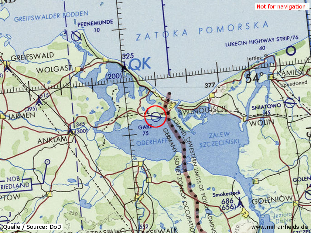
Garz Airfield on a map of the US Department of Defense from 1972
Source: ONC E-2 (1972), Perry-Castañeda Library Map Collection, University of Texas at Austin
Overview
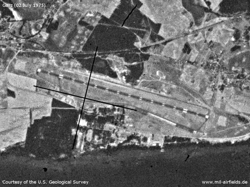
Garz Airfield on a US satellite image from 02 July 1975 - In comparison with the 1969 picture, the northern taxiway has been added. In addition, the runway now has a different marking.
Source: U.S. Geological Survey
Temporary deployment of Fighter Wing 8 to Garz 1975
Because of construction work at the Marxwalde airfield the East German fighter wing 8 was temporarily stationed at the Garz airfield.
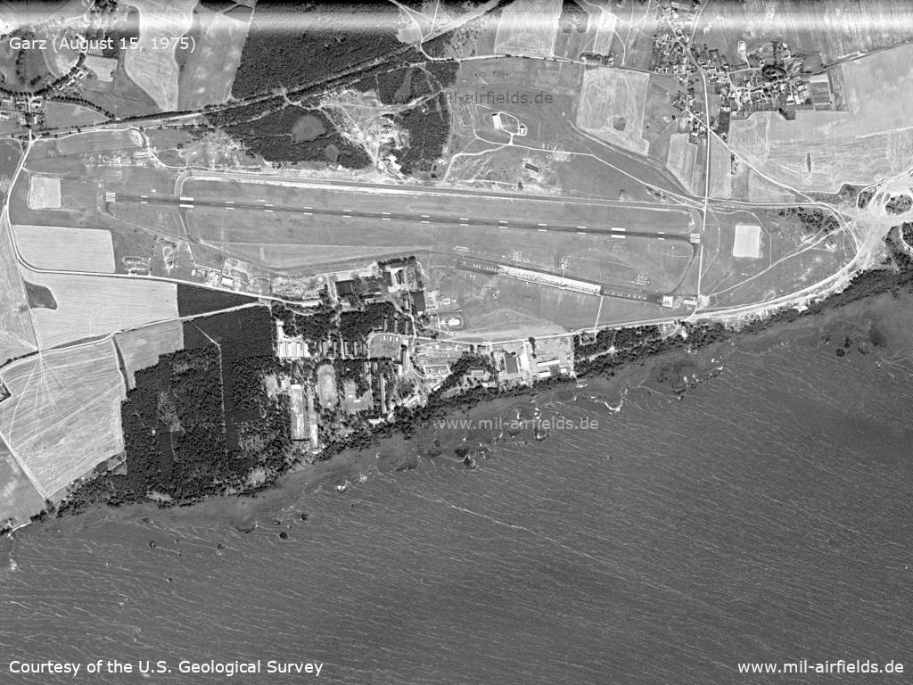
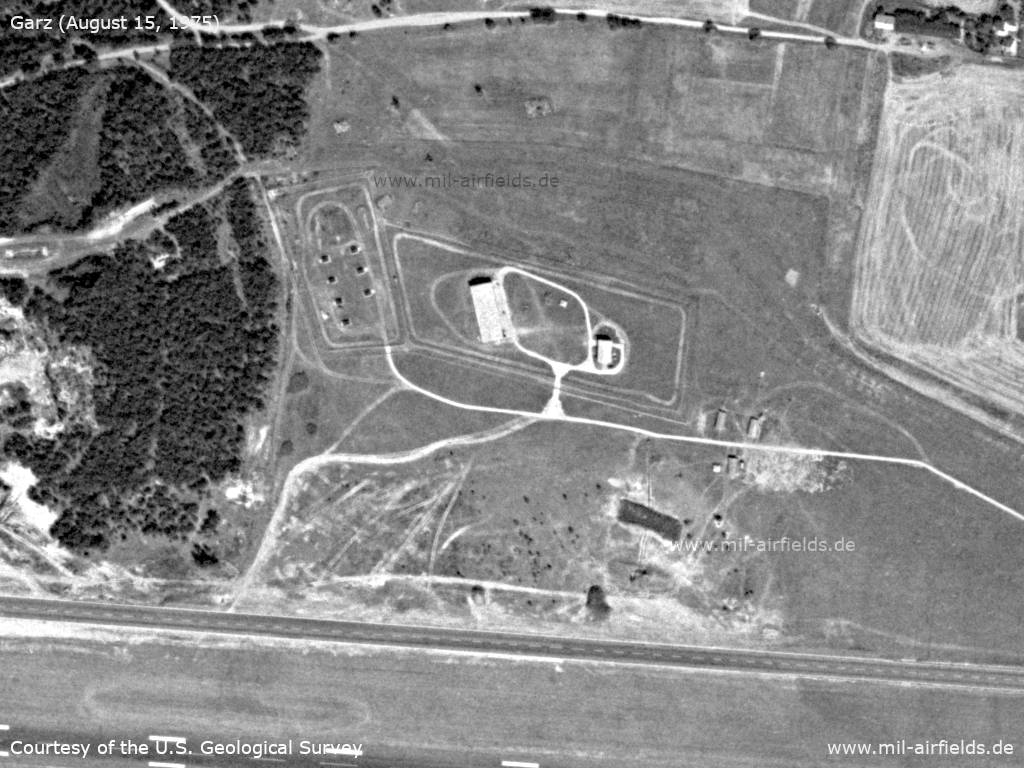
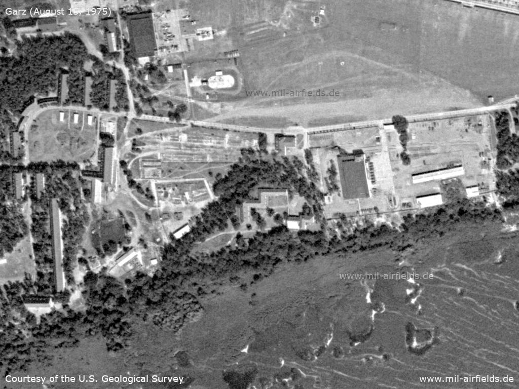
The airfield on August 15, 1975 - Aerial photo/satellite image Garz/Heringsdorf airfield East Germany 1975
Source: U.S. Geological Survey
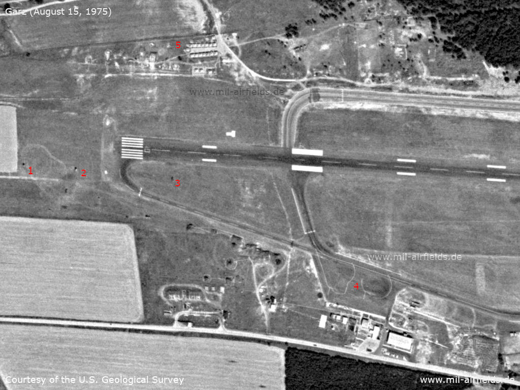
Western runway threshold - (1), (2), (3): Possible spotlight vehicles for the approach from the west; (4): Civil apron; (5) To the north is a tent city.
Source: U.S. Geological Survey
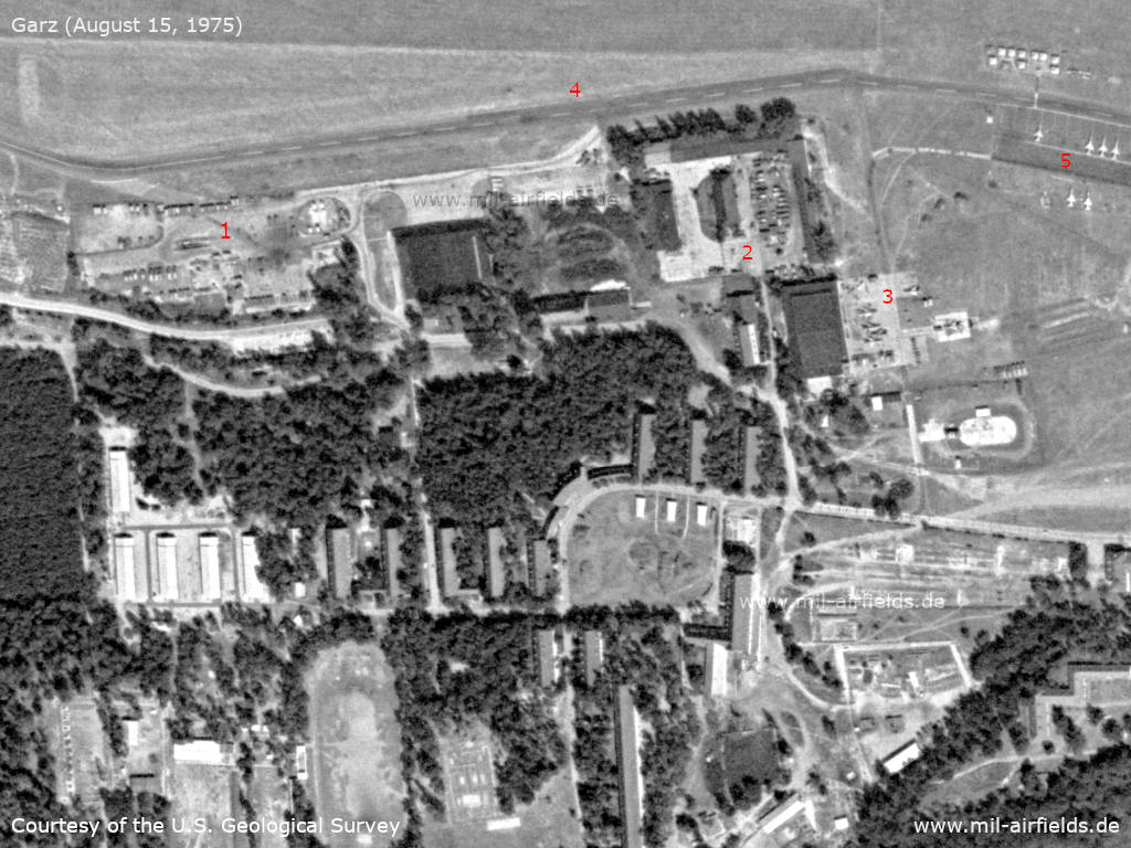
Buildung complex - (1), (2): Vehicles, (3): Hangar, (4): Taxiway, (5): Flight line
Source: U.S. Geological Survey
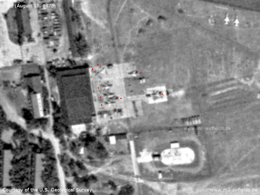
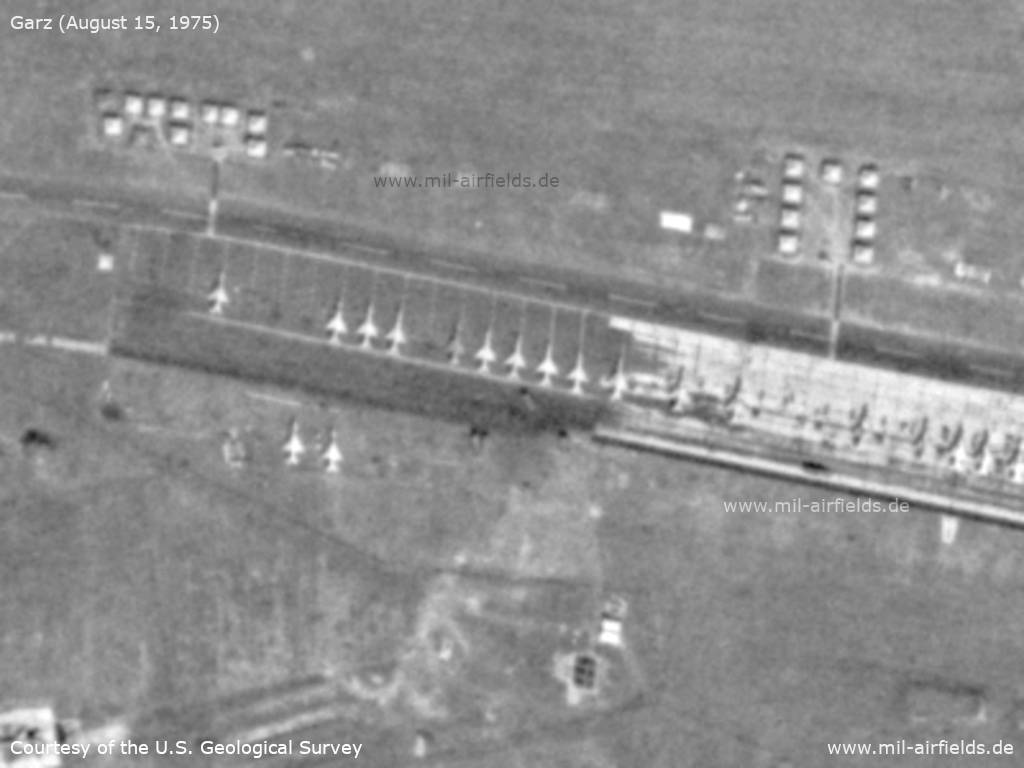
Hangar - In front of the eastern hangar are 8 MiG-21s, each marked with a red dot behind the tail here on the picture
Source: U.S. Geological Survey
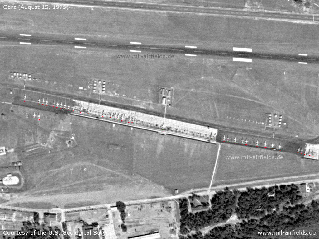
Flight line - At the flight line there are 37 MiG-21s in total, two of them parked on the grass. In front of it there are several tent areas.
Source: U.S. Geological Survey
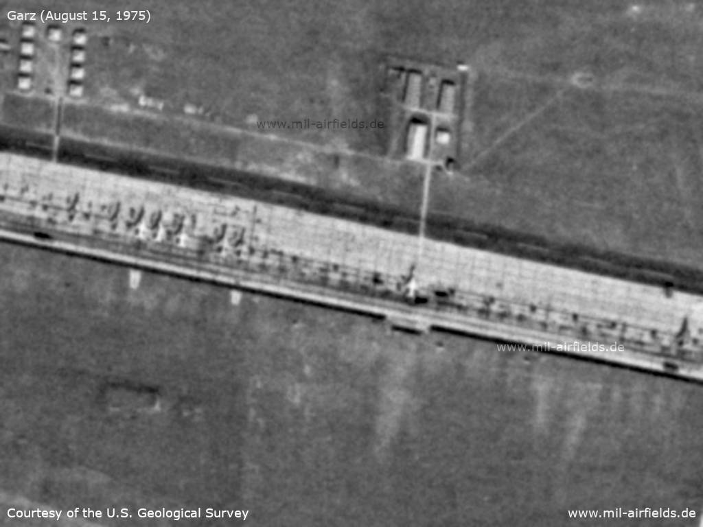
Enlargement - Flight line and tents, western part
Source: U.S. Geological Survey
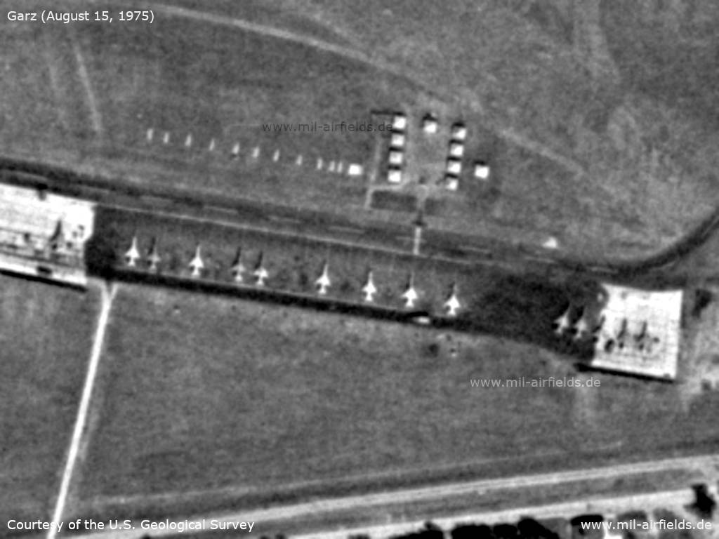
Enlargement - Flight line and tents, central part
Source: U.S. Geological Survey
Enlargement - Flight line and tents, eastern part
Source: U.S. Geological Survey
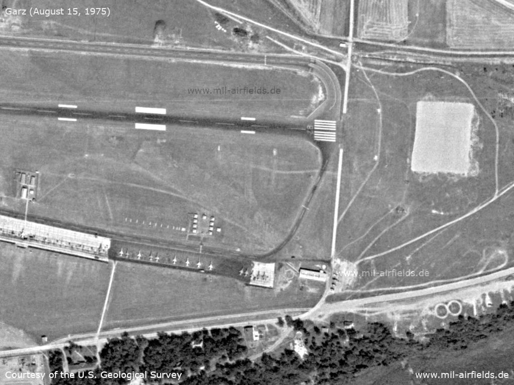
Eastern threshold
Source: U.S. Geological Survey
Installations in the north
Source: U.S. Geological Survey
Southern part - In the southern part there is another hangar
Source: U.S. Geological Survey
Airspace
Luftstraße W-6 Friedland - Heringsdorf, Stand Mitte der 1970er Jahre
Die Mittellinie der Luftstraße W-6 führte über die Funknavigationsanlagen NDB Friedland (N534611 E0133456) und NDB Heringsdorf (N535234 E0141103).
Luftstraßenbreite: 7 km.
Höhenbereich:
- Beim Einflug in die Luftstraße A4: obere Grenze 3050 m STD, untere Grenze 1850 m STD
- Beim Einflug in die Flughafenkontrollzone: obere Grenze 1500 m, untere Grenze 600 m AGL.
Luftstraßenbreite: 7 km.
Höhenbereich:
- Beim Einflug in die Luftstraße A4: obere Grenze 3050 m STD, untere Grenze 1850 m STD
- Beim Einflug in die Flughafenkontrollzone: obere Grenze 1500 m, untere Grenze 600 m AGL.
Zivile Kontrollzone des Flugplatzes Heringsdorf Stand Mitte der 1970er Jahre
Seitliche Begrenzung: Ahlbeck - Lubin - Rieth - Usedom - Ahlbeck. Es gab verschiedene Höhenbereiche: 0 m bis 1500 m AAL, 0 m bis 1200 m AAL und 0 m bis 800 m AAL.
Die Kontrollzone hatte nur während des Saisonbetriebs oder bei bestätigten Sonderflügen Gültigkeit. Der Flughafen hatte keinen Nahbereich.
In the 1980s and early 1990s
Overview
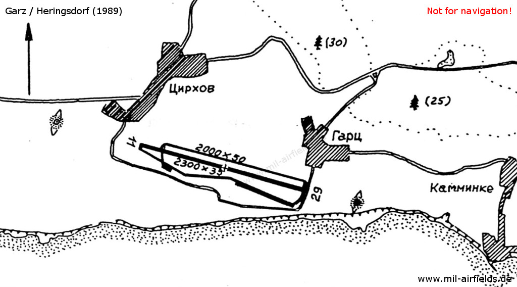
Garz airfield on a map in the East German "Directory 012" (Verzeichnis 012, formerly "Top Secret") from about 1989/1990. - Hand-drawn maps were not unusual in the Eastern bloc. The location with the villages Zirchow, Garz and Kamminke can be seen. East of Kamminke is the border to poland (not shown here). The airfield has a hard-surfaced runway of 2.300 m length. The taxiway in the north is also available with 2000 m as a runway. To the northwest and south-east, the locator beacons are marked with dot-filled circles and with ellipses for the middle markers.
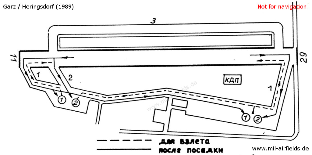
Runway and taxi tracks for take-off (dashed lines) and after landing (solid lines) - still from Directory 012 - In the Warsaw Pact, taxiways had numbers.
Runways
- 11/29: 2300 m x 35 m Bitumen
- 11/29: 2000 m x 50 m Grass runway north of the bitumen runway
- 11/29: 1900 m x 35 m Taxiway 3 (now taxiway D) als emergency runway
Radio beacons
- LOM: 679,5 "GZ", 4200 m
- LMM: 330,0 "G", 610 m
- KRM/GRM: Channel 38
- LOM: 679,5 "ZG", 4160 m
- LMM: 330,0 "G", 1160 m
Die Kennungen der Funkfeuer wurden, wie im Warschauer Pakt üblich, aus dem ersten und letzten Buchstaben des Rufzeichens abgeleitet (GESETZ). Für Garz wurde ein Rufzeichen gewählt, bei dem diese Buchstaben mit dem Ortsnamen (Garz) übereinstimmen. Das war aber nur selten der Fall.
Radar
1989: ASR/PAR
Radio communication
The call sign was GESETZ.
Standard training routes
"Flüge der LSK/LV der NVA und der LSK der GSSD im Rahmen der Gefechtsausbildung sind entsprechend der Grafik der Flugtage / -nächte auf der Grundlage der "Hauptflugregeln zum Fliegen im Luftraum der Deutschen Demokratischen Republik" auf Standardflugstrecken in den dazu festgelegten Flughöhen durchzuführen. ..." (Quelle: "Verzeichnis der Standardflugstrecken der LSK/LV der NVA und der LSK der GSSD")
Year 1989:
Der Flugplatz Garz hatte die Anmeldungsnummern 640-659.
642 Garz, Leopoldshagen, Neubrandenburg, Alt Schönau, Poggendorf, Garz
Flughöhe: 100 ... 2450 m (unter SWB 5500 m, 6100 m)
Höheneinnahme: Leopoldshagen
Höhenaufgabe: Traverse Wolgast
Abfangabschnitt: Leopoldshagen, Traverse Wolgast
(nach Abstimmung mit VHZ)
Flughöhe: 100 ... 2450 m (unter SWB 5500 m, 6100 m)
Höheneinnahme: Leopoldshagen
Höhenaufgabe: Traverse Wolgast
Abfangabschnitt: Leopoldshagen, Traverse Wolgast
(nach Abstimmung mit VHZ)
644 Garz, Bergen, Dranske, 54°37' n.B., 12°29' ö.L., 54°24' n.B. 12°12' ö.L., Rechtskurve, 54°37' n.B. 12°29' ö.L., Putgarten, 54°03'30'' n.B. 14°10'30'' ö.L., Garz
Flughöhe: 300 ... 10650 m
Höheneinnahme: 54°43' n.B. 12°45' ö.L., 54°37' n.B. 12°29' ö.L.
Höhenaufgabe: Traverse Sassnitz
Abfangabschnitt: 54°37' n.B., 12°29' ö.L., 54°24' n.B. 12°12' ö.L.
Flughöhe: 300 ... 10650 m
Höheneinnahme: 54°43' n.B. 12°45' ö.L., 54°37' n.B. 12°29' ö.L.
Höhenaufgabe: Traverse Sassnitz
Abfangabschnitt: 54°37' n.B., 12°29' ö.L., 54°24' n.B. 12°12' ö.L.
646 Garz, Bergen, 54°47' n.B., 13°17' ö.L., 54°40' n.B. 14°30' ö.L., 54°03'30'' n.B. 14°10'30'' ö.L., Garz
Flughöhe: 300 ... 10650 m
Höheneinnahme: Traverse Dranske
Höhenaufgabe: Greifswalder Oie
Abfangabschnitt: Bergen, 54°40' n.B. 14°30' ö.L.
Flughöhe: 300 ... 10650 m
Höheneinnahme: Traverse Dranske
Höhenaufgabe: Greifswalder Oie
Abfangabschnitt: Bergen, 54°40' n.B. 14°30' ö.L.
648 Garz, Bergen, Schwaan, 54°53' n.B., 14°00' ö.L., 54°40' n.B. 14°30' ö.L., 54°03'30'' n.B. 14°10'30'' ö.L., Garz
Flughöhe: 10050 m, 10650 m
Höheneinnahme: Traverse Franzburg
Höhenaufgabe: 54°40' n.B. 14°30' ö.L.
Abfangabschnitt: Schwaan, 54°40' n.B. 14°30' ö.L.
Flughöhe: 10050 m, 10650 m
Höheneinnahme: Traverse Franzburg
Höhenaufgabe: 54°40' n.B. 14°30' ö.L.
Abfangabschnitt: Schwaan, 54°40' n.B. 14°30' ö.L.
649 Garz, Bergen, Schwaan, 54°53' n.B., 14°00' ö.L., 54°40' n.B. 14°30' ö.L., 54°03'30'' n.B. 14°10'30'' ö.L., Garz
Flughöhe: 11000 ... 18000 m
Höheneinnahme: Traverse Franzburg
Höhenaufgabe: 54°53' n.B. 14°00' ö.L.
Abfangabschnitt: Kühlungsborn, 54°53' n.B. 14°00' ö.L.
Flughöhe: 11000 ... 18000 m
Höheneinnahme: Traverse Franzburg
Höhenaufgabe: 54°53' n.B. 14°00' ö.L.
Abfangabschnitt: Kühlungsborn, 54°53' n.B. 14°00' ö.L.
650 Garz, Bergen, Schwaan, 54°47' n.B., 13°17' ö.L., 54°03'30'' n.B. 14°10'30'' ö.L., Garz
Flughöhe: 100 ... 6100 m
Höheneinnahme: Bergen
Höhenaufgabe: Traverse Greifswalder Oie
Abfangabschnitt: Bergen, Traverse Greifswalder Oie
Flughöhe: 100 ... 6100 m
Höheneinnahme: Bergen
Höhenaufgabe: Traverse Greifswalder Oie
Abfangabschnitt: Bergen, Traverse Greifswalder Oie
Units
Feldflugplatzkommando 9 (FFlpK-9) (PF 65277)
Real property
| Installation Id | Object | Area | Quarters | Address |
|---|---|---|---|---|
| 01/913 | Airfield | 289,2 ha | 955 | |
| 01/922 | Radio beacon | 74,2 ha | ||
| 01/926 | Radio beacon | 2,5 ha | ||
| 01/932 | Radio beacon | 1,0 ha | ||
| 01/934 | Radio beacon | 1,0 ha | ||
| 01/935 | Radio beacon | 1,0 ha |
Today
Use
Civilian airfield (EDAH).
Overview
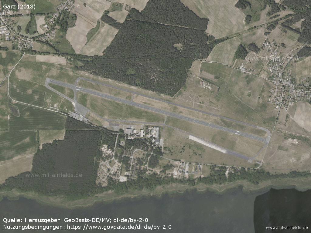
Aerial image from 2018
Source: Landesamt für innere Verwaltung M-V, Amt für Geoinformation, Vermessung und Katasterwesen - www.geoportal-mv.de, Datenlizenz Deutschland – Namensnennung – Version 2.0, www.govdata.de/dl-de/by-2-0
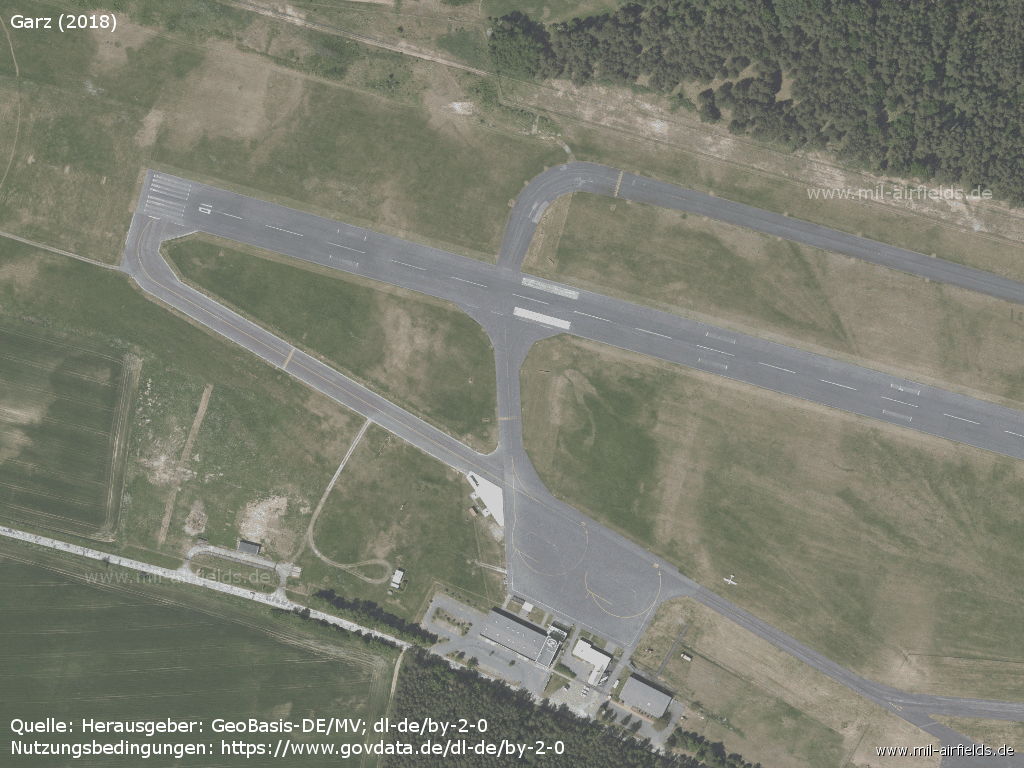
Runway 10
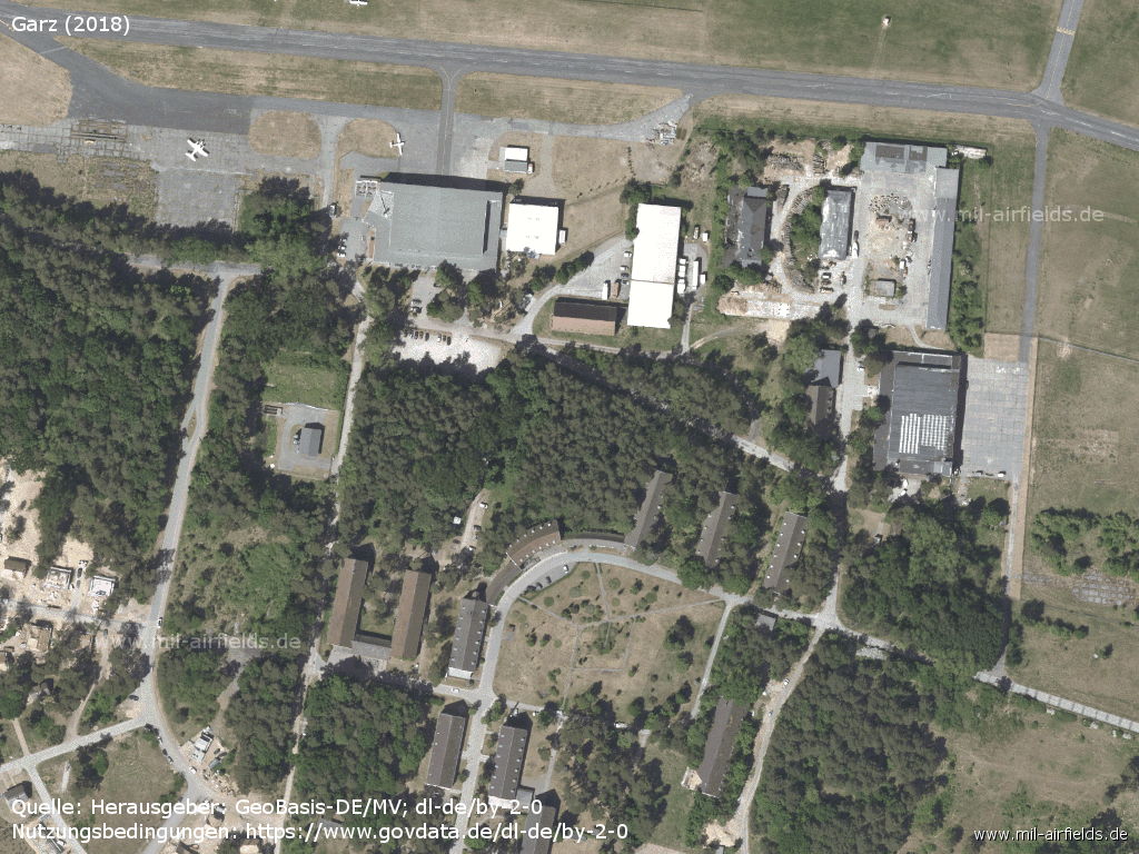
Hangars
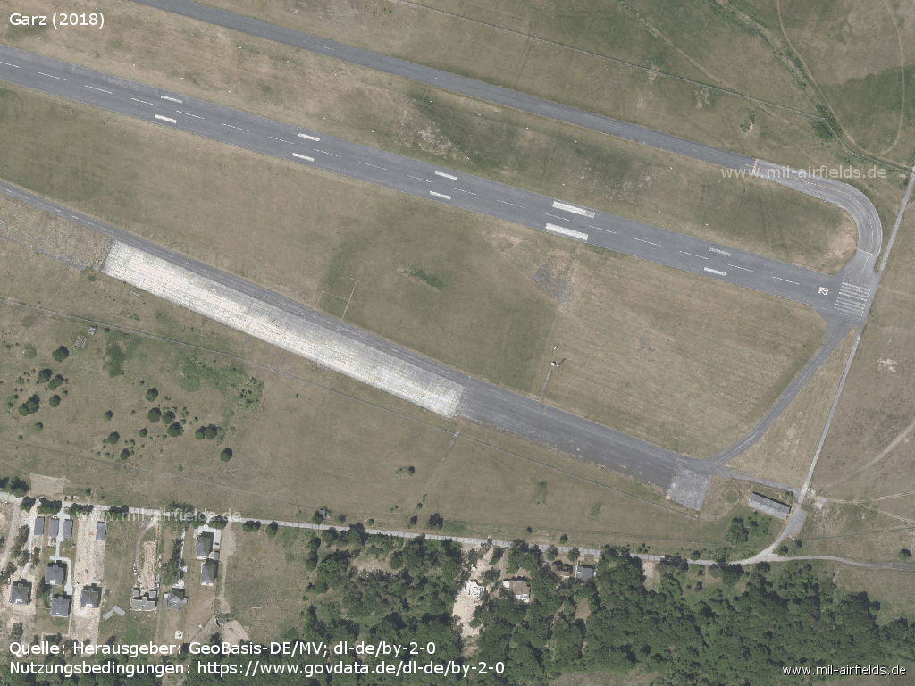
Runway 28 and flight line
Sources
- http://lib.byu.edu/collections/german-maps/http://... - German Maps (Topographische Karte 1:25,000)German Maps (Topographische Karte 1:25,000)
- https://www.geoportal-mv.de/ - GeoPortal.MV
Links
- http://www.flughafen-heringsdorf.de/ - Flughafen Heringsdorf
Bibliography
- Ries, Karl; Dierich, Wolfgang: "Fliegerhorste und Einsatzhäfen der Luftwaffe" Motorbuch Verlag Stuttgart, 1993 - Allied map
- Grenzdörfer, Joachim; Seifert, Karl-Dieter: "Geschichte der ostdeutschen Verkehrsflughäfen" Bernard & Graefe Verlag, Bonn, 1997 - 8 pages description, maps, aerial picture 1994
- Freundt, Lutz (Hrsg.), Büttner, Stefan: "Rote Plätze - Russische Militärflugplätze in Deutschland 1945 - 1994" AeroLit Verlag, 2007 - Short description, aerial picture 1953
- Kanetzki, Manfred: "MiGs über Peenemünde" AeroLit - Verlag und Medienvertrieb, Diepholz (2001) - Short description, some pictures
Related topics
Airfields in the vicinity
- 322°/11km Pudagla: Helipad 3360 (HSLP / HLP 3360)
- 161°/15km Altwarp: Helipad 3332 (HSLP / HLP 3332)
- 292°/23km Lassan: Agricultural Airfield
- 297°/28km Seckeritz: Agricultural Airfield
Categories
Military Airfields GermanyMilitary Airfields in former East GermanyAir bases of former National People's ArmyRecommended
Image credits are shown on the respective target page, click on the preview to open it.
 Follow mil-airfields on Facebook